Yujiahe geodata
Yujiahe (Jiangxi) is a seat of a fourth-order administrative division; located in China in Asia/Shanghai (GMT+8) time zone. In our database, there are 1268 cities with bigger population. Compared to other cities in China, 57.6% of cities are located further ↑North; 60.3% of cities are located further ←West and 83.4% of cities have higher elevation than Yujiahe. Note1


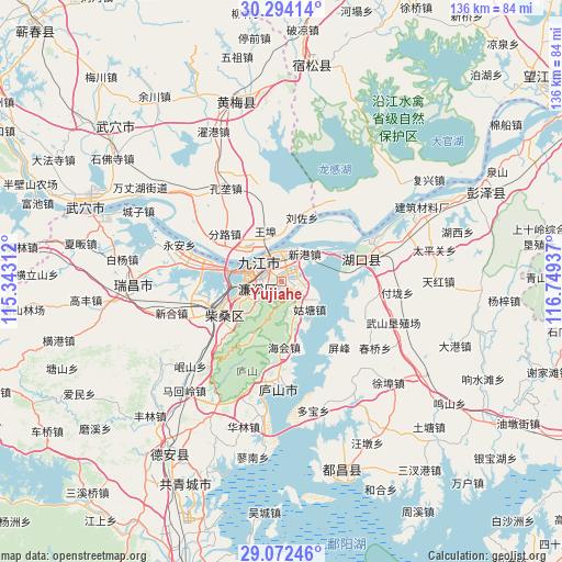
Yujiahe GPS coordinates[2]
29° 41' 6.576" North, 116° 2' 46.464" East
| Map corner | latitude | longitude |
|---|---|---|
| Upper-left | 30.29414°, | 115.34312° |
| Center: | 29.68516°, | 116.04624° |
| Lower-right: | 29.07246°, | 116.74937° |
| Map W x H: | 135.8×135.8 km | = 84.4×84.4mi |
| max Lat: | 53.31946° ⇑57.6% North |
| Yujiahe: | 29.68516° |
| min Lat: | ⇓42.4% South 18.22056° |
| min Long | Yujiahe | max Long |
| 75.07348° | 116.04624° | 134.28917° |
| W 60.3%⇐ | ⇒39.7% E |
Elevation
Elevation of Yujiahe is 19 m = 62 ft, and this is 465.8 m = 1528 ft below average elevation for this country.
| Max E: |
5622 m = 18445 ft | 83.4% |
| Avg. | 484.8 m = 1591 ft | |
| Yujiahe | 19 m = 62 ft | |
Min E: |
-3 m = -10 ft | 16.6% |
See also: China elevation on elevation.city.
Geographical zone
Yujiahe is located in North temperate zone (between Tropic of Cancer and the Arctic Circle). Distance of this Northern Tropic circle is 694.8 km =431.7 mi to South.| Distance of | km | miles | from Yujiahe |
|---|---|---|---|
| North Pole | 6706.4 | 4167.2 | to North |
| Arctic Circle | 4100.5 | 2547.9 | to North |
| Tropic Cancer | 694.8 | 431.7 | to South |
| Equator | 3300.7 | 2051 | to South |


Nearby cities:
15 places around Yujiahe: (largest is in red/bold)
• Bailu
22.1 km =13.7 mi,  181°
181°
• Fenlu
18 km =11.2 mi,  309°
309°
• Guling
14.6 km =9.1 mi,  207°
207°
• Gutang
9.9 km =6.2 mi,  135°
135°
• Haihui
15.8 km =9.8 mi, 177°
• Jiangzhou
13.4 km =8.3 mi,  32°
32°
• Jiujiang
4.8 km =3 mi,  297°
297°
• Lianhua
8.1 km =5 mi,  232°
232°
• Liuzuo
16.1 km =10 mi,  17°
17°
• Saiyang
16.7 km =10.4 mi,  224°
224°
• Shahejie
17.6 km =10.9 mi,  240°
240°
• Shizi
22.3 km =13.9 mi,  245°
245°
• Shuangzhong
18.4 km =11.4 mi,  69°
69°
• Xiaochi
9.4 km =5.8 mi,  324°
324°
• Xingang
9.1 km =5.7 mi, 32°
Sources, notices
• [Note1] Compared only with cities in China existing in our database
• [Src1] Map data: © OpenStreetMap contributors (CC-BY-SA)
• [Src2] Other city data from geonames.org with taken over terms of usage.
• [Src3] Geographical zone / Annual Mean Temperature by Robert A. Rohde @ Wikipedia
