Xinchang geodata
Xinchang (Hubei) is a seat of a fourth-order administrative division; located in China in Asia/Shanghai (GMT+8) time zone. In our database, there are 1268 cities with bigger population. Compared to other cities in China, 55.2% of cities are located further ↑North; 60.4% of cities are located further →East and 73.7% of cities have higher elevation than Xinchang. Note1


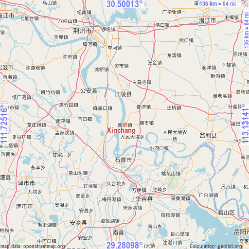
Xinchang GPS coordinates[2]
29° 53' 32.712" North, 112° 25' 41.808" East
| Map corner | latitude | longitude |
|---|---|---|
| Upper-left | 30.50013°, | 111.72516° |
| Center: | 29.89242°, | 112.42828° |
| Lower-right: | 29.28098°, | 113.13141° |
| Map W x H: | 135.6×135.6 km | = 84.3×84.3mi |
| max Lat: | 53.31946° ⇑55.2% North |
| Xinchang: | 29.89242° |
| min Lat: | ⇓44.8% South 18.22056° |
| min Long | Xinchang | max Long |
| 75.07348° | 112.42828° | 134.28917° |
| W 39.6%⇐ | ⇒60.4% E |
Elevation
Elevation of Xinchang is 40 m = 131 ft, and this is 444.8 m = 1459 ft below average elevation for this country.
| Max E: |
5622 m = 18445 ft | 73.7% |
| Avg. | 484.8 m = 1591 ft | |
| Xinchang | 40 m = 131 ft | |
Min E: |
-3 m = -10 ft | 26.3% |
See also: China elevation on elevation.city.
Geographical zone
Xinchang is located in North temperate zone (between Tropic of Cancer and the Arctic Circle). Distance of this Northern Tropic circle is 717.8 km =446 mi to South.| Distance of | km | miles | from Xinchang |
|---|---|---|---|
| North Pole | 6683.3 | 4152.8 | to North |
| Arctic Circle | 4077.4 | 2533.6 | to North |
| Tropic Cancer | 717.8 | 446 | to South |
| Equator | 3323.7 | 2065.3 | to South |


Nearby cities:
15 places around Xinchang: (largest is in red/bold)
• Chengji
20.6 km =12.8 mi,  76°
76°
• Dongsheng
21.6 km =13.4 mi,  154°
154°
• Gaoling
20.8 km =12.9 mi,  212°
212°
• Haoxue
17.7 km =11 mi,  12°
12°
• Hengshi
11.8 km =7.3 mi, 84°
• Mahaokou
15.2 km =9.4 mi,  307°
307°
• Nankou
18.3 km =11.4 mi, 210°
• Ouchi
19 km =11.8 mi, 214°
• Puji
14.2 km =8.8 mi,  45°
45°
• Qinshi
18.6 km =11.6 mi,  62°
62°
• Renmindayuan
7.5 km =4.7 mi, 147°
• Xionghe
21.4 km =13.3 mi,  3°
3°
• Xiulin
19.7 km =12.2 mi,  187°
187°
• Zhakou
22.1 km =13.7 mi,  278°
278°
• Zhangtiansi
22 km =13.7 mi,  258°
258°
Sources, notices
• [Note1] Compared only with cities in China existing in our database
• [Src1] Map data: © OpenStreetMap contributors (CC-BY-SA)
• [Src2] Other city data from geonames.org with taken over terms of usage.
• [Src3] Geographical zone / Annual Mean Temperature by Robert A. Rohde @ Wikipedia
