Qinshi geodata
Qinshi (Hubei) is a seat of a fourth-order administrative division; located in China in Asia/Shanghai (GMT+8) time zone. In our database, there are 1268 cities with bigger population. Compared to other cities in China, 54.4% of cities are located further ↑North; 59.5% of cities are located further →East and 78.3% of cities have higher elevation than Qinshi. Note1


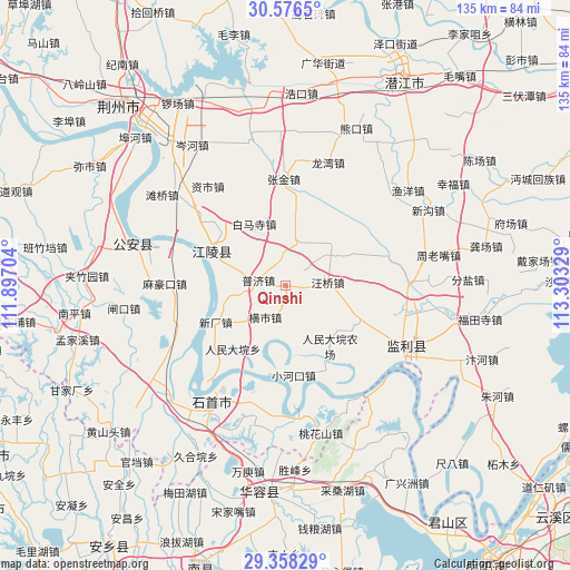
Qinshi GPS coordinates[2]
29° 58' 9.336" North, 112° 36' 0.576" East
| Map corner | latitude | longitude |
|---|---|---|
| Upper-left | 30.5765°, | 111.89704° |
| Center: | 29.96926°, | 112.60016° |
| Lower-right: | 29.35829°, | 113.30329° |
| Map W x H: | 135.5×135.5 km | = 84.2×84.2mi |
| max Lat: | 53.31946° ⇑54.4% North |
| Qinshi: | 29.96926° |
| min Lat: | ⇓45.6% South 18.22056° |
| min Long | Qinshi | max Long |
| 75.07348° | 112.60016° | 134.28917° |
| W 40.5%⇐ | ⇒59.5% E |
Elevation
Elevation of Qinshi is 30 m = 98 ft, and this is 454.8 m = 1492 ft below average elevation for this country.
| Max E: |
5622 m = 18445 ft | 78.3% |
| Avg. | 484.8 m = 1591 ft | |
| Qinshi | 30 m = 98 ft | |
Min E: |
-3 m = -10 ft | 21.7% |
See also: China elevation on elevation.city.
Geographical zone
Qinshi is located in North temperate zone (between Tropic of Cancer and the Arctic Circle). Distance of this Northern Tropic circle is 726.4 km =451.4 mi to South.| Distance of | km | miles | from Qinshi |
|---|---|---|---|
| North Pole | 6674.8 | 4147.5 | to North |
| Arctic Circle | 4068.9 | 2528.3 | to North |
| Tropic Cancer | 726.4 | 451.4 | to South |
| Equator | 3332.3 | 2070.6 | to South |


Nearby cities:
15 places around Qinshi: (largest is in red/bold)
• Baimasi
16.5 km =10.3 mi,  333°
333°
• Chengji
5 km =3.1 mi,  136°
136°
• Dongsheng
29 km =18 mi,  194°
194°
• Haoxue
15.5 km =9.6 mi,  304°
304°
• Hengshi
8.8 km =5.5 mi,  213°
213°
• Huangxiekou
25.3 km =15.7 mi,  73°
73°
• Mahaokou
28.7 km =17.8 mi,  271°
271°
• Puji
6.6 km =4.1 mi,  282°
282°
• Renmindayuan
19.5 km =12.1 mi,  220°
220°
• Shagang
11.3 km =7 mi,  16°
16°
• Wangqiao
10.1 km =6.3 mi,  84°
84°
• Xiaohekou
21.3 km =13.2 mi,  174°
174°
• Xinchang
18.6 km =11.6 mi,  242°
242°
• Xionghe
19.8 km =12.3 mi,  310°
310°
• Zhangjin
25.4 km =15.8 mi,  359°
359°
Sources, notices
• [Note1] Compared only with cities in China existing in our database
• [Src1] Map data: © OpenStreetMap contributors (CC-BY-SA)
• [Src2] Other city data from geonames.org with taken over terms of usage.
• [Src3] Geographical zone / Annual Mean Temperature by Robert A. Rohde @ Wikipedia
