Dongsheng geodata
Dongsheng (Hubei) is a seat of a fourth-order administrative division; located in China in Asia/Shanghai (GMT+8) time zone. In our database, there are 1268 cities with bigger population. Compared to other cities in China, 57.2% of cities are located further ↑North; 60% of cities are located further →East and 75.7% of cities have higher elevation than Dongsheng. Note1


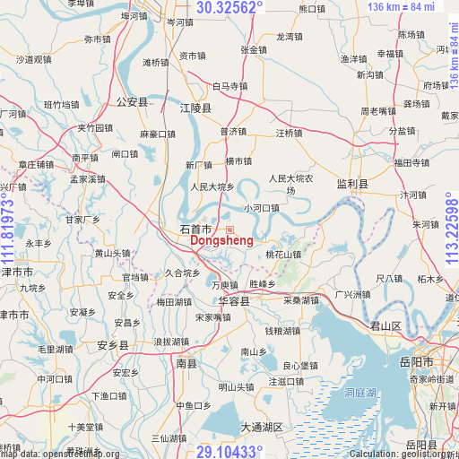
Dongsheng GPS coordinates[2]
29° 43' 0.588" North, 112° 31' 22.26" East
| Map corner | latitude | longitude |
|---|---|---|
| Upper-left | 30.32562°, | 111.81973° |
| Center: | 29.71683°, | 112.52285° |
| Lower-right: | 29.10433°, | 113.22598° |
| Map W x H: | 135.8×135.8 km | = 84.4×84.4mi |
| max Lat: | 53.31946° ⇑57.2% North |
| Dongsheng: | 29.71683° |
| min Lat: | ⇓42.8% South 18.22056° |
| min Long | Dongsheng | max Long |
| 75.07348° | 112.52285° | 134.28917° |
| W 40%⇐ | ⇒60% E |
Elevation
Elevation of Dongsheng is 35 m = 115 ft, and this is 449.8 m = 1476 ft below average elevation for this country.
| Max E: |
5622 m = 18445 ft | 75.7% |
| Avg. | 484.8 m = 1591 ft | |
| Dongsheng | 35 m = 115 ft | |
Min E: |
-3 m = -10 ft | 24.3% |
See also: China elevation on elevation.city.
Geographical zone
Dongsheng is located in North temperate zone (between Tropic of Cancer and the Arctic Circle). Distance of this Northern Tropic circle is 698.3 km =433.9 mi to South.| Distance of | km | miles | from Dongsheng |
|---|---|---|---|
| North Pole | 6702.9 | 4165 | to North |
| Arctic Circle | 4097 | 2545.8 | to North |
| Tropic Cancer | 698.3 | 433.9 | to South |
| Equator | 3304.2 | 2053.1 | to South |


Nearby cities:
15 places around Dongsheng: (largest is in red/bold)
• Diaoguan
10.4 km =6.5 mi,  105°
105°
• Gaojimiao
12.6 km =7.8 mi,  228°
228°
• Gaoling
20.5 km =12.7 mi,  275°
275°
• Hengshi
20.9 km =13 mi,  7°
7°
• Huarong Chengguanzhen
22.1 km =13.7 mi,  173°
173°
• Jiaoshanhe
7.9 km =4.9 mi,  148°
148°
• Jiuheyuan
18.6 km =11.6 mi, 228°
• Nankou
18.9 km =11.7 mi, 281°
• Ouchi
20.3 km =12.6 mi, 281°
• Renmindayuan
14.1 km =8.8 mi,  338°
338°
• Taohuashan
17.3 km =10.7 mi, 113°
• Tuanshansi
23.4 km =14.5 mi,  237°
237°
• Xiaohekou
11.7 km =7.3 mi,  54°
54°
• Xinchang
21.6 km =13.4 mi,  334°
334°
• Xiulin
11.9 km =7.4 mi,  269°
269°
Sources, notices
• [Note1] Compared only with cities in China existing in our database
• [Src1] Map data: © OpenStreetMap contributors (CC-BY-SA)
• [Src2] Other city data from geonames.org with taken over terms of usage.
• [Src3] Geographical zone / Annual Mean Temperature by Robert A. Rohde @ Wikipedia
