Ouchi geodata
Ouchi (Hubei) is a seat of a fourth-order administrative division; located in China in Asia/Shanghai (GMT+8) time zone. In our database, there are 1268 cities with bigger population. Compared to other cities in China, 56.9% of cities are located further ↑North; 61.1% of cities are located further →East and 75.7% of cities have higher elevation than Ouchi. Note1


Ouchi GPS coordinates[2]
29° 45' 6.228" North, 112° 18' 57.996" East
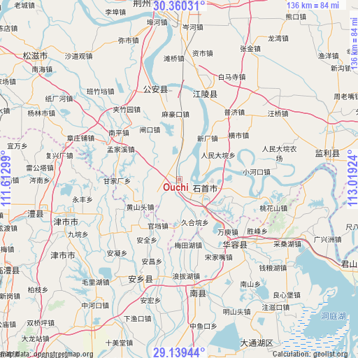
| Map corner | latitude | longitude |
|---|---|---|
| Upper-left | 30.36031°, | 111.61299° |
| Center: | 29.75173°, | 112.31611° |
| Lower-right: | 29.13944°, | 113.01924° |
| Map W x H: | 135.7×135.7 km | = 84.3×84.3mi |
| max Lat: | 53.31946° ⇑56.9% North |
| Ouchi: | 29.75173° |
| min Lat: | ⇓43.1% South 18.22056° |
| min Long | Ouchi | max Long |
| 75.07348° | 112.31611° | 134.28917° |
| W 38.9%⇐ | ⇒61.1% E |
Elevation
Elevation of Ouchi is 35 m = 115 ft, and this is 449.8 m = 1476 ft below average elevation for this country.
| Max E: |
5622 m = 18445 ft | 75.7% |
| Avg. | 484.8 m = 1591 ft | |
| Ouchi | 35 m = 115 ft | |
Min E: |
-3 m = -10 ft | 24.3% |
See also: China elevation on elevation.city.
Geographical zone
Ouchi is located in North temperate zone (between Tropic of Cancer and the Arctic Circle). Distance of this Northern Tropic circle is 702.2 km =436.3 mi to South.| Distance of | km | miles | from Ouchi |
|---|---|---|---|
| North Pole | 6699 | 4162.6 | to North |
| Arctic Circle | 4093.1 | 2543.3 | to North |
| Tropic Cancer | 702.2 | 436.3 | to South |
| Equator | 3308.1 | 2055.6 | to South |


Nearby cities:
15 places around Ouchi: (largest is in red/bold)
• Dongsheng
20.3 km =12.6 mi,  101°
101°
• Ganjiachang
24.1 km =15 mi,  269°
269°
• Gaojimiao
16.2 km =10.1 mi,  139°
139°
• Gaoling
1.9 km =1.2 mi,  194°
194°
• Jiaoqi
25.4 km =15.8 mi,  243°
243°
• Jiuheyuan
17.3 km =10.7 mi,  159°
159°
• Mahaokou
24.8 km =15.4 mi,  356°
356°
• Mengjiaxi
24.8 km =15.4 mi,  297°
297°
• Nankou
1.4 km =0.9 mi,  91°
91°
• Renmindayuan
17.5 km =10.9 mi,  58°
58°
• Tuanshansi
16.3 km =10.1 mi,  179°
179°
• Xinchang
19 km =11.8 mi,  34°
34°
• Xiulin
9 km =5.6 mi,  115°
115°
• Zhakou
21.9 km =13.6 mi,  329°
329°
• Zhangtiansi
15.6 km =9.7 mi,  316°
316°
Sources, notices
• [Note1] Compared only with cities in China existing in our database
• [Src1] Map data: © OpenStreetMap contributors (CC-BY-SA)
• [Src2] Other city data from geonames.org with taken over terms of usage.
• [Src3] Geographical zone / Annual Mean Temperature by Robert A. Rohde @ Wikipedia
