Xiulin geodata
Xiulin (Hubei) is a populated place; located in China in Asia/Shanghai (GMT+8) time zone. With population of 122,411 people, there are 361 cities with bigger population in this country. Compared to other cities in China, 57.3% of cities are located further ↑North; 60.6% of cities are located further →East and 75.3% of cities have higher elevation than Xiulin. Note1


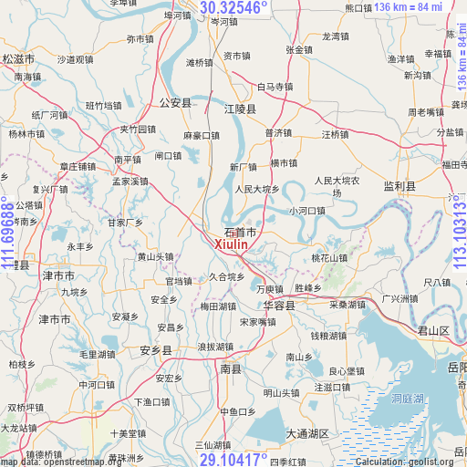
Xiulin GPS coordinates[2]
29° 43' 0.012" North, 112° 24' 0" East
| Map corner | latitude | longitude |
|---|---|---|
| Upper-left | 30.32546°, | 111.69688° |
| Center: | 29.71667°, | 112.4° |
| Lower-right: | 29.10417°, | 113.10313° |
| Map W x H: | 135.8×135.8 km | = 84.4×84.4mi |
| max Lat: | 53.31946° ⇑57.3% North |
| Xiulin: | 29.71667° |
| min Lat: | ⇓42.7% South 18.22056° |
| min Long | Xiulin | max Long |
| 75.07348° | 112.4° | 134.28917° |
| W 39.4%⇐ | ⇒60.6% E |
Elevation
Elevation of Xiulin is 36 m = 118 ft, and this is 448.8 m = 1472 ft below average elevation for this country.
| Max E: |
5622 m = 18445 ft | 75.3% |
| Avg. | 484.8 m = 1591 ft | |
| Xiulin | 36 m = 118 ft | |
Min E: |
-3 m = -10 ft | 24.7% |
See also: Xiulin elevation on elevation.city.
Geographical zone
Xiulin is located in North temperate zone (between Tropic of Cancer and the Arctic Circle). Distance of this Northern Tropic circle is 698.3 km =433.9 mi to South.| Distance of | km | miles | from Xiulin |
|---|---|---|---|
| North Pole | 6702.9 | 4165 | to North |
| Arctic Circle | 4097 | 2545.8 | to North |
| Tropic Cancer | 698.3 | 433.9 | to South |
| Equator | 3304.2 | 2053.1 | to South |


Nearby cities:
15 places around Xiulin: (largest is in red/bold)
• Diaoguan
22.1 km =13.7 mi,  97°
97°
• Dongsheng
11.9 km =7.4 mi,  89°
89°
• Gaojimiao
8.7 km =5.4 mi,  163°
163°
• Gaoling
8.8 km =5.5 mi,  283°
283°
• Hengshi
25.3 km =15.7 mi,  35°
35°
• Jiaoshanhe
17.4 km =10.8 mi,  112°
112°
• Jiuheyuan
12.5 km =7.8 mi,  189°
189°
• Meitianhu
21.7 km =13.5 mi, 189°
• Nankou
7.7 km =4.8 mi,  299°
299°
• Ouchi
9 km =5.6 mi, 295°
• Renmindayuan
14.8 km =9.2 mi,  27°
27°
• Tuanshansi
14.8 km =9.2 mi,  212°
212°
• Xiaohekou
22.4 km =13.9 mi,  72°
72°
• Xinchang
19.7 km =12.2 mi,  7°
7°
• Zhangtiansi
24.2 km =15 mi,  308°
308°
Sources, notices
• [Note1] Compared only with cities in China existing in our database
• [Src1] Map data: © OpenStreetMap contributors (CC-BY-SA)
• [Src2] Other city data from geonames.org with taken over terms of usage.
• [Src3] Geographical zone / Annual Mean Temperature by Robert A. Rohde @ Wikipedia
