Hai’an geodata
Hai’an (Guangdong) is a seat of a fourth-order administrative division; located in China in Asia/Urumqi (GMT+6) time zone. In our database, there are 1268 cities with bigger population. Compared to other cities in China, 98.7% of cities are located further ↑North; 70.3% of cities are located further →East and 80.2% of cities have higher elevation than Hai’an. Note1


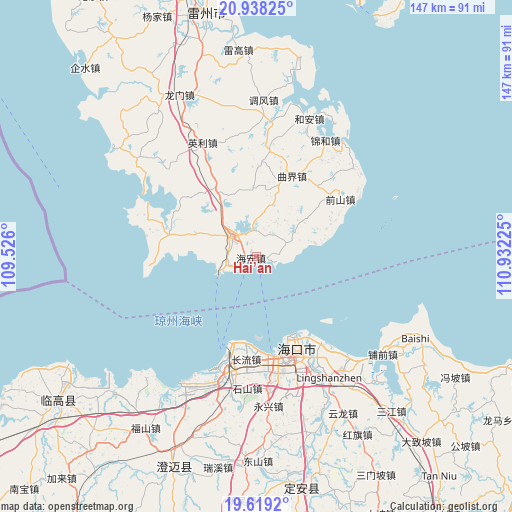
Hai’an GPS coordinates[2]
20° 16' 48.468" North, 110° 13' 44.832" East
| Map corner | latitude | longitude |
|---|---|---|
| Upper-left | 20.93825°, | 109.526° |
| Center: | 20.28013°, | 110.22912° |
| Lower-right: | 19.6192°, | 110.93225° |
| Map W x H: | 146.7×146.7 km | = 91.2×91.2mi |
| max Lat: | 53.31946° ⇑98.7% North |
| Hai’an: | 20.28013° |
| min Lat: | ⇓1.3% South 18.22056° |
| min Long | Hai’an | max Long |
| 75.07348° | 110.22912° | 134.28917° |
| W 29.7%⇐ | ⇒70.3% E |
Elevation
Elevation of Hai’an is 26 m = 85 ft, and this is 458.8 m = 1505 ft below average elevation for this country.
| Max E: |
5622 m = 18445 ft | 80.2% |
| Avg. | 484.8 m = 1591 ft | |
| Hai’an | 26 m = 85 ft | |
Min E: |
-3 m = -10 ft | 19.8% |
See also: China elevation on elevation.city.
Geographical zone
Hai’an is located in North Torrid zone (between Equator and Tropic of Cancer). Distance of this Northern Tropic circle is 351 km =218.1 mi to North.| Distance of | km | miles | from Hai’an |
|---|---|---|---|
| North Pole | 7752.1 | 4816.9 | to North |
| Arctic Circle | 5146.2 | 3197.7 | to North |
| Tropic Cancer | 351 | 218.1 | to North |
| Equator | 2254.9 | 1401.1 | to South |


Nearby cities:
15 places around Hai’an: (largest is in red/bold)
• Changliu
29.8 km =18.5 mi,  185°
185°
• Chengbei
7.3 km =4.5 mi,  312°
312°
• Dongying
31.8 km =19.8 mi,  142°
142°
• Haikou
28.6 km =17.8 mi,  155°
155°
• Haixiu
30.3 km =18.8 mi,  170°
170°
• Jiaoweixiang
28 km =17.4 mi,  267°
267°
• Longtang
12.7 km =7.9 mi,  68°
68°
• Maichen
25.2 km =15.7 mi,  284°
284°
• Nanshan
7.7 km =4.8 mi,  298°
298°
• Qianshan
29.2 km =18.1 mi,  56°
56°
• Qujie
25 km =15.5 mi,  23°
23°
• Xiaqiao
21.3 km =13.2 mi,  331°
331°
• Xilian
31.6 km =19.6 mi,  290°
290°
• Xiuying
31.8 km =19.8 mi, 167°
• Xucheng
8.5 km =5.3 mi, 310°
Sources, notices
• [Note1] Compared only with cities in China existing in our database
• [Src1] Map data: © OpenStreetMap contributors (CC-BY-SA)
• [Src2] Other city data from geonames.org with taken over terms of usage.
• [Src3] Geographical zone / Annual Mean Temperature by Robert A. Rohde @ Wikipedia
