Shaxi geodata
Shaxi (Zhejiang) is a seat of a fourth-order administrative division; located in China in Asia/Shanghai (GMT+8) time zone. In our database, there are 1268 cities with bigger population. Compared to other cities in China, 59.5% of cities are located further ↑North; 88.3% of cities are located further ←West and 51.3% of cities have higher elevation than Shaxi. Note1


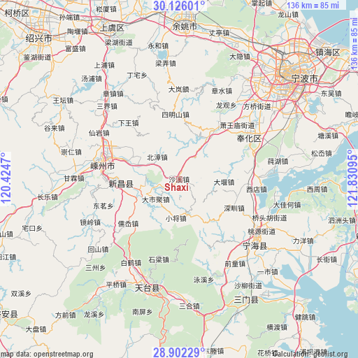
Shaxi GPS coordinates[2]
29° 30' 57.6" North, 121° 7' 40.152" East
| Map corner | latitude | longitude |
|---|---|---|
| Upper-left | 30.12601°, | 120.4247° |
| Center: | 29.516°, | 121.12782° |
| Lower-right: | 28.90229°, | 121.83095° |
| Map W x H: | 136.1×136.1 km | = 84.6×84.6mi |
| max Lat: | 53.31946° ⇑59.5% North |
| Shaxi: | 29.516° |
| min Lat: | ⇓40.5% South 18.22056° |
| min Long | Shaxi | max Long |
| 75.07348° | 121.12782° | 134.28917° |
| W 88.3%⇐ | ⇒11.7% E |
Elevation
Elevation of Shaxi is 154 m = 505 ft, and this is 330.8 m = 1085 ft below average elevation for this country.
| Max E: |
5622 m = 18445 ft | 51.3% |
| Avg. | 484.8 m = 1591 ft | |
| Shaxi | 154 m = 505 ft | |
Min E: |
-3 m = -10 ft | 48.7% |
See also: China elevation on elevation.city.
Geographical zone
Shaxi is located in North temperate zone (between Tropic of Cancer and the Arctic Circle). Distance of this Northern Tropic circle is 676 km =420 mi to South.| Distance of | km | miles | from Shaxi |
|---|---|---|---|
| North Pole | 6725.2 | 4178.8 | to North |
| Arctic Circle | 4119.3 | 2559.6 | to North |
| Tropic Cancer | 676 | 420 | to South |
| Equator | 3281.9 | 2039.3 | to South |


Nearby cities:
15 places around Shaxi: (largest is in red/bold)
• Beizhang
11.9 km =7.4 mi,  314°
314°
• Dashiju
12 km =7.5 mi,  228°
228°
• Dayan
16.6 km =10.3 mi,  93°
93°
• Feikeng
27.5 km =17.1 mi,  157°
157°
• Huangze
21 km =13 mi,  289°
289°
• Pukou
29.3 km =18.2 mi,  296°
296°
• Ru’ao
26.9 km =16.7 mi, 229°
• Shangtian
29.1 km =18.1 mi,  67°
67°
• Shenzhen
23.3 km =14.5 mi,  118°
118°
• Simingshan
24.5 km =15.2 mi,  356°
356°
• Xiaojiang
14.8 km =9.2 mi,  184°
184°
• Xiaren
11.5 km =7.1 mi, 301°
• Xidian
29.7 km =18.5 mi,  95°
95°
• Xikou
23.6 km =14.7 mi,  36°
36°
• Xinchang Chengguanzhen
22.1 km =13.7 mi,  266°
266°
Sources, notices
• [Note1] Compared only with cities in China existing in our database
• [Src1] Map data: © OpenStreetMap contributors (CC-BY-SA)
• [Src2] Other city data from geonames.org with taken over terms of usage.
• [Src3] Geographical zone / Annual Mean Temperature by Robert A. Rohde @ Wikipedia
