Bange geodata
Bange (Ningxia Hui Autonomous Region) is a seat of a fourth-order administrative division; located in China in Asia/Shanghai (GMT+8) time zone. In our database, there are 1268 cities with bigger population. Compared to other cities in China, 77% of cities are located further ↓South; 87.4% of cities are located further →East and 93.9% of cities have lower elevation than Bange. Note1


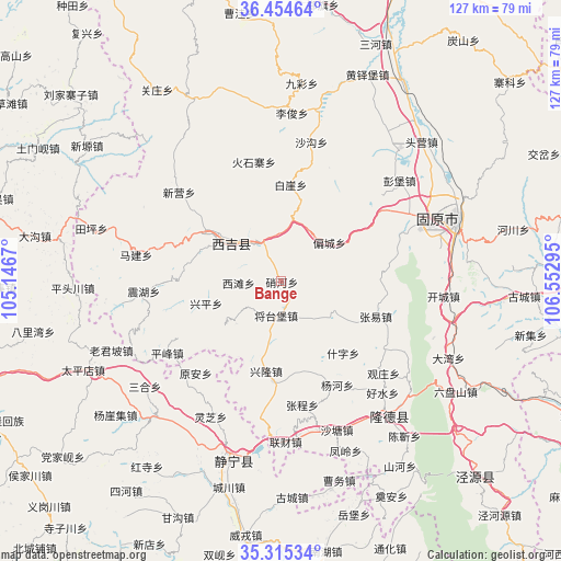
Bange GPS coordinates[2]
35° 53' 13.344" North, 105° 50' 59.352" East
| Map corner | latitude | longitude |
|---|---|---|
| Upper-left | 36.45464°, | 105.1467° |
| Center: | 35.88704°, | 105.84982° |
| Lower-right: | 35.31534°, | 106.55295° |
| Map W x H: | 126.7×126.7 km | = 78.7×78.7mi |
| max Lat: | 53.31946° ⇑23% North |
| Bange: | 35.88704° |
| min Lat: | ⇓77% South 18.22056° |
| min Long | Bange | max Long |
| 75.07348° | 105.84982° | 134.28917° |
| W 12.6%⇐ | ⇒87.4% E |
Elevation
Elevation of Bange is 1847 m = 6060 ft, and this is 1362.2 m = 4469 ft above average elevation for this country.
| Max E: |
5622 m = 18445 ft | 6.1% |
| Bange | 1847 m 6060 ft | |
| Avg. | 484.8 m = 1591 ft | |
Min E: |
-3 m = -10 ft | 93.9% |
See also: China elevation on elevation.city.
Geographical zone
Bange is located in North temperate zone (between Tropic of Cancer and the Arctic Circle). Distance of this Northern Tropic circle is 1384.3 km =860.2 mi to South.| Distance of | km | miles | from Bange |
|---|---|---|---|
| North Pole | 6016.8 | 3738.7 | to North |
| Arctic Circle | 3410.9 | 2119.4 | to North |
| Tropic Cancer | 1384.3 | 860.2 | to South |
| Equator | 3990.3 | 2479.5 | to South |


Nearby cities:
15 places around Bange: (largest is in red/bold)
• Gongyi
24.7 km =15.3 mi,  207°
207°
• Haoshui
34.7 km =21.6 mi,  139°
139°
• Liancai
36.4 km =22.6 mi,  178°
178°
• Malianchuan
10.9 km =6.8 mi, 142°
• Pengbao
35.1 km =21.8 mi,  49°
49°
• Piancheng
13.9 km =8.6 mi, 50°
• Pingfeng
30.6 km =19 mi,  238°
238°
• Shatang
35.9 km =22.3 mi,  159°
159°
• Shenlin
34.8 km =21.6 mi,  168°
168°
• Wangmin
14 km =8.7 mi,  226°
226°
• Xinglong
20.7 km =12.9 mi,  190°
190°
• Xingping
17.8 km =11.1 mi,  253°
253°
• Xitan
9.8 km =6.1 mi,  267°
267°
• Yuan’an
28.4 km =17.6 mi,  223°
223°
• Zhonghe
33.4 km =20.8 mi,  60°
60°
Sources, notices
• [Note1] Compared only with cities in China existing in our database
• [Src1] Map data: © OpenStreetMap contributors (CC-BY-SA)
• [Src2] Other city data from geonames.org with taken over terms of usage.
• [Src3] Geographical zone / Annual Mean Temperature by Robert A. Rohde @ Wikipedia
