Haoshui geodata
Haoshui (Ningxia Hui Autonomous Region) is a seat of a fourth-order administrative division; located in China in Asia/Shanghai (GMT+8) time zone. In our database, there are 1268 cities with bigger population. Compared to other cities in China, 76.4% of cities are located further ↓South; 86.5% of cities are located further →East and 95.1% of cities have lower elevation than Haoshui. Note1


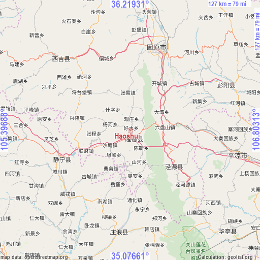
Haoshui GPS coordinates[2]
35° 39' 0" North, 106° 6' 0" East
| Map corner | latitude | longitude |
|---|---|---|
| Upper-left | 36.21931°, | 105.39688° |
| Center: | 35.65°, | 106.1° |
| Lower-right: | 35.07661°, | 106.80313° |
| Map W x H: | 127.1×127.1 km | = 79×79mi |
| max Lat: | 53.31946° ⇑23.6% North |
| Haoshui: | 35.65° |
| min Lat: | ⇓76.4% South 18.22056° |
| min Long | Haoshui | max Long |
| 75.07348° | 106.1° | 134.28917° |
| W 13.5%⇐ | ⇒86.5% E |
Elevation
Elevation of Haoshui is 2169 m = 7116 ft, and this is 1684.2 m = 5526 ft above average elevation for this country.
| Max E: |
5622 m = 18445 ft | 4.9% |
| Haoshui | 2169 m 7116 ft | |
| Avg. | 484.8 m = 1591 ft | |
Min E: |
-3 m = -10 ft | 95.1% |
See also: China elevation on elevation.city.
Geographical zone
Haoshui is located in North temperate zone (between Tropic of Cancer and the Arctic Circle). Distance of this Northern Tropic circle is 1358 km =843.8 mi to South.| Distance of | km | miles | from Haoshui |
|---|---|---|---|
| North Pole | 6043.2 | 3755.1 | to North |
| Arctic Circle | 3437.3 | 2135.8 | to North |
| Tropic Cancer | 1358 | 843.8 | to South |
| Equator | 3963.9 | 2463.1 | to South |


Nearby cities:
15 places around Haoshui: (largest is in red/bold)
• Bange
34.7 km =21.6 mi,  319°
319°
• Chenjin
10.3 km =6.4 mi,  153°
153°
• Gongyi
34.5 km =21.4 mi,  277°
277°
• Jingning Chengguanzhen
37 km =23 mi,  247°
247°
• Liancai
23.9 km =14.9 mi, 245°
• Longde Chengguanzhen
4.4 km =2.7 mi,  160°
160°
• Malianchuan
23.8 km =14.8 mi, 318°
• Nanhu
37 km =23 mi,  200°
200°
• Shanhe
15.5 km =9.6 mi, 163°
• Shatang
12.5 km =7.8 mi,  234°
234°
• Shenlin
17.6 km =10.9 mi,  243°
243°
• Wangmin
36.9 km =22.9 mi,  297°
297°
• Xiangshui
28.4 km =17.6 mi,  132°
132°
• Xinglong
26.9 km =16.7 mi, 282°
• Xingsheng
30.7 km =19.1 mi,  136°
136°
Sources, notices
• [Note1] Compared only with cities in China existing in our database
• [Src1] Map data: © OpenStreetMap contributors (CC-BY-SA)
• [Src2] Other city data from geonames.org with taken over terms of usage.
• [Src3] Geographical zone / Annual Mean Temperature by Robert A. Rohde @ Wikipedia
