Xiaodian geodata
Xiaodian (Tianjin) is a seat of a fourth-order administrative division; located in China in Asia/Shanghai (GMT+8) time zone. With population of 5,086 people, there are 868 cities with bigger population in this country. Compared to other cities in China, 83.9% of cities are located further ↓South; 67.4% of cities are located further ←West and 95.9% of cities have higher elevation than Xiaodian. Note1


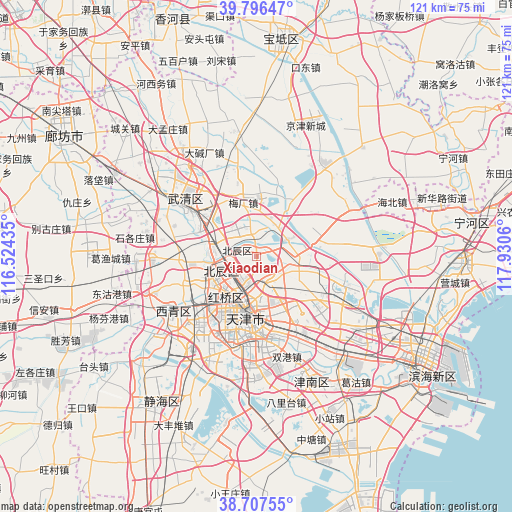
Xiaodian GPS coordinates[2]
39° 15' 14.832" North, 117° 13' 38.892" East
| Map corner | latitude | longitude |
|---|---|---|
| Upper-left | 39.79647°, | 116.52435° |
| Center: | 39.25412°, | 117.22747° |
| Lower-right: | 38.70755°, | 117.9306° |
| Map W x H: | 121.1×121.1 km | = 75.2×75.2mi |
| max Lat: | 53.31946° ⇑16.1% North |
| Xiaodian: | 39.25412° |
| min Lat: | ⇓83.9% South 18.22056° |
| min Long | Xiaodian | max Long |
| 75.07348° | 117.22747° | 134.28917° |
| W 67.4%⇐ | ⇒32.6% E |
Elevation
Elevation of Xiaodian is 6 m = 20 ft, and this is 478.8 m = 1571 ft below average elevation for this country.
| Max E: |
5622 m = 18445 ft | 95.9% |
| Avg. | 484.8 m = 1591 ft | |
| Xiaodian | 6 m = 20 ft | |
Min E: |
-3 m = -10 ft | 4.1% |
See also: China elevation on elevation.city.
Geographical zone
Xiaodian is located in North temperate zone (between Tropic of Cancer and the Arctic Circle). Distance of this Northern Tropic circle is 1758.7 km =1092.8 mi to South.| Distance of | km | miles | from Xiaodian |
|---|---|---|---|
| North Pole | 5642.4 | 3506 | to North |
| Arctic Circle | 3036.5 | 1886.8 | to North |
| Tropic Cancer | 1758.7 | 1092.8 | to South |
| Equator | 4364.6 | 2712 | to South |


Nearby cities:
15 places around Xiaodian: (largest is in red/bold)
• Beicang
9.3 km =5.8 mi,  257°
257°
• Dabizhuang
7.2 km =4.5 mi,  160°
160°
• Dazhangzhuang
3.5 km =2.2 mi,  357°
357°
• Guoyuan Xincun
9.1 km =5.7 mi,  246°
246°
• Huantuo
8.9 km =5.5 mi,  110°
110°
• Huozhuangzi
8.5 km =5.3 mi,  60°
60°
• Jianchangdao
9.5 km =5.9 mi,  182°
182°
• Liukuaizhuang
9.7 km =6 mi,  94°
94°
• Liu’anzhuang
3.1 km =1.9 mi,  235°
235°
• Mazhuang
9.5 km =5.9 mi, 238°
• Nancang
9.6 km =6 mi,  234°
234°
• Tiedonglu
7.6 km =4.7 mi,  199°
199°
• Xinkaihe
9.7 km =6 mi,  205°
205°
• Yixingfu
6.3 km =3.9 mi,  192°
192°
• Zhaoguli
9.8 km =6.1 mi,  172°
172°
Sources, notices
• [Note1] Compared only with cities in China existing in our database
• [Src1] Map data: © OpenStreetMap contributors (CC-BY-SA)
• [Src2] Other city data from geonames.org with taken over terms of usage.
• [Src3] Geographical zone / Annual Mean Temperature by Robert A. Rohde @ Wikipedia
