Xianlin geodata
Xianlin (Zhejiang) is a seat of a fourth-order administrative division; located in China in Asia/Shanghai (GMT+8) time zone. In our database, there are 1268 cities with bigger population. Compared to other cities in China, 51.9% of cities are located further ↑North; 81.8% of cities are located further ←West and 87.7% of cities have higher elevation than Xianlin. Note1


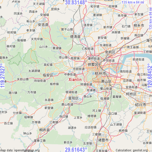
Xianlin GPS coordinates[2]
30° 13' 32.988" North, 119° 58' 53.004" East
| Map corner | latitude | longitude |
|---|---|---|
| Upper-left | 30.83148°, | 119.27827° |
| Center: | 30.22583°, | 119.98139° |
| Lower-right: | 29.61643°, | 120.68452° |
| Map W x H: | 135.1×135.1 km | = 83.9×83.9mi |
| max Lat: | 53.31946° ⇑51.9% North |
| Xianlin: | 30.22583° |
| min Lat: | ⇓48.1% South 18.22056° |
| min Long | Xianlin | max Long |
| 75.07348° | 119.98139° | 134.28917° |
| W 81.8%⇐ | ⇒18.2% E |
Elevation
Elevation of Xianlin is 12 m = 39 ft, and this is 472.8 m = 1551 ft below average elevation for this country.
| Max E: |
5622 m = 18445 ft | 87.7% |
| Avg. | 484.8 m = 1591 ft | |
| Xianlin | 12 m = 39 ft | |
Min E: |
-3 m = -10 ft | 12.3% |
See also: China elevation on elevation.city.
Geographical zone
Xianlin is located in North temperate zone (between Tropic of Cancer and the Arctic Circle). Distance of this Northern Tropic circle is 754.9 km =469.1 mi to South.| Distance of | km | miles | from Xianlin |
|---|---|---|---|
| North Pole | 6646.3 | 4129.8 | to North |
| Arctic Circle | 4040.4 | 2510.6 | to North |
| Tropic Cancer | 754.9 | 469.1 | to South |
| Equator | 3360.8 | 2088.3 | to South |


Nearby cities:
15 places around Xianlin: (largest is in red/bold)
• Cangqian
7.3 km =4.5 mi,  7°
7°
• Dongzhou
16.4 km =10.2 mi,  178°
178°
• Gaoqiao
14.4 km =8.9 mi,  197°
197°
• Gudang
14.4 km =8.9 mi,  66°
66°
• Jiangcun
10.4 km =6.5 mi,  50°
50°
• Liuxia
7.2 km =4.5 mi, 72°
• Qingshanhu
16.5 km =10.3 mi,  279°
279°
• Sandun
14.4 km =8.9 mi,  40°
40°
• Shoujiang
11.2 km =7 mi,  190°
190°
• Xiangfu
16.2 km =10.1 mi, 44°
• Xihu
13.3 km =8.3 mi,  82°
82°
• Yuhang
7.2 km =4.5 mi,  319°
319°
• Zhongtai
5.5 km =3.4 mi,  287°
287°
• Zhoupu
16.9 km =10.5 mi,  151°
151°
• Zhuantang
11.4 km =7.1 mi,  127°
127°
Sources, notices
• [Note1] Compared only with cities in China existing in our database
• [Src1] Map data: © OpenStreetMap contributors (CC-BY-SA)
• [Src2] Other city data from geonames.org with taken over terms of usage.
• [Src3] Geographical zone / Annual Mean Temperature by Robert A. Rohde @ Wikipedia
