Zhuhai geodata
Zhuhai (Guangdong) is a seat of a second-order administrative division; located in China in Asia/Shanghai (GMT+8) time zone. With population of 501,199 people, there are 128 cities with bigger population in this country. Compared to other cities in China, 96.8% of cities are located further ↑North; 53.9% of cities are located further →East and 75.7% of cities have higher elevation than Zhuhai. Note1


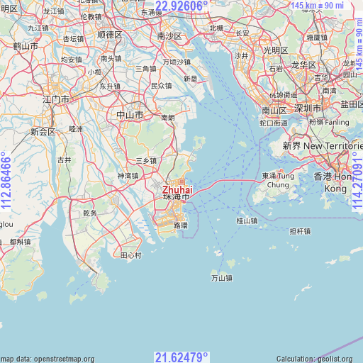
Zhuhai GPS coordinates[2]
22° 16' 36.984" North, 113° 34' 4.008" East
| Map corner | latitude | longitude |
|---|---|---|
| Upper-left | 22.92606°, | 112.86466° |
| Center: | 22.27694°, | 113.56778° |
| Lower-right: | 21.62479°, | 114.27091° |
| Map W x H: | 144.7×144.7 km | = 89.9×89.9mi |
| max Lat: | 53.31946° ⇑96.8% North |
| Zhuhai: | 22.27694° |
| min Lat: | ⇓3.2% South 18.22056° |
| min Long | Zhuhai | max Long |
| 75.07348° | 113.56778° | 134.28917° |
| W 46.1%⇐ | ⇒53.9% E |
Elevation
Elevation of Zhuhai is 35 m = 115 ft, and this is 449.8 m = 1476 ft below average elevation for this country.
| Max E: |
5622 m = 18445 ft | 75.7% |
| Avg. | 484.8 m = 1591 ft | |
| Zhuhai | 35 m = 115 ft | |
Min E: |
-3 m = -10 ft | 24.3% |
See also: Zhuhai elevation on elevation.city.
Geographical zone
Zhuhai is located in North Torrid zone (between Equator and Tropic of Cancer). Distance of this Northern Tropic circle is 129 km =80.2 mi to North.| Distance of | km | miles | from Zhuhai |
|---|---|---|---|
| North Pole | 7530.1 | 4679 | to North |
| Arctic Circle | 4924.2 | 3059.8 | to North |
| Tropic Cancer | 129 | 80.2 | to North |
| Equator | 2477 | 1539.1 | to South |


Nearby cities:
15 places around Zhuhai: (largest is in red/bold)
• Banfu
29.6 km =18.4 mi,  299°
299°
• Dongqu
31.5 km =19.6 mi,  327°
327°
• Hongqi
27.3 km =17 mi,  238°
238°
• Huancheng
29.6 km =18.4 mi,  317°
317°
• Jida
2.5 km =1.6 mi,  174°
174°
• Jing’an
29.3 km =18.2 mi,  255°
255°
• Nanlang
24.1 km =15 mi,  352°
352°
• Nanping
9.2 km =5.7 mi,  231°
231°
• Qianshan
6.1 km =3.8 mi, 232°
• Sanxiang
17.2 km =10.7 mi, 298°
• Shenwan
20.5 km =12.7 mi,  274°
274°
• Tangjiawan
9.8 km =6.1 mi,  17°
17°
• Tanzhou
10.7 km =6.6 mi, 256°
• Wanzai
9.3 km =5.8 mi,  206°
206°
• Wuguishan
20.1 km =12.5 mi,  314°
314°
Sources, notices
• [Note1] Compared only with cities in China existing in our database
• [Src1] Map data: © OpenStreetMap contributors (CC-BY-SA)
• [Src2] Other city data from geonames.org with taken over terms of usage.
• [Src3] Geographical zone / Annual Mean Temperature by Robert A. Rohde @ Wikipedia
