Tanzhou geodata
Tanzhou (Guangdong) is a seat of a fourth-order administrative division; located in China in Asia/Shanghai (GMT+8) time zone. In our database, there are 1268 cities with bigger population. Compared to other cities in China, 96.8% of cities are located further ↑North; 54.5% of cities are located further →East and 99.4% of cities have higher elevation than Tanzhou. Note1


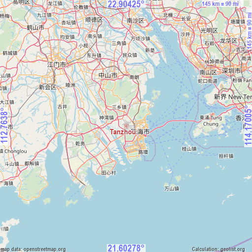
Tanzhou GPS coordinates[2]
22° 15' 18.108" North, 113° 28' 0.912" East
| Map corner | latitude | longitude |
|---|---|---|
| Upper-left | 22.90425°, | 112.7638° |
| Center: | 22.25503°, | 113.46692° |
| Lower-right: | 21.60278°, | 114.17005° |
| Map W x H: | 144.7×144.7 km | = 89.9×89.9mi |
| max Lat: | 53.31946° ⇑96.8% North |
| Tanzhou: | 22.25503° |
| min Lat: | ⇓3.2% South 18.22056° |
| min Long | Tanzhou | max Long |
| 75.07348° | 113.46692° | 134.28917° |
| W 45.5%⇐ | ⇒54.5% E |
Elevation
Elevation of Tanzhou is 2 m = 7 ft, and this is 482.8 m = 1584 ft below average elevation for this country.
| Max E: |
5622 m = 18445 ft | 99.4% |
| Avg. | 484.8 m = 1591 ft | |
| Tanzhou | 2 m = 7 ft | |
Min E: |
-3 m = -10 ft | 0.6% |
See also: China elevation on elevation.city.
Geographical zone
Tanzhou is located in North Torrid zone (between Equator and Tropic of Cancer). Distance of this Northern Tropic circle is 131.4 km =81.6 mi to North.| Distance of | km | miles | from Tanzhou |
|---|---|---|---|
| North Pole | 7532.5 | 4680.5 | to North |
| Arctic Circle | 4926.6 | 3061.2 | to North |
| Tropic Cancer | 131.4 | 81.6 | to North |
| Equator | 2474.5 | 1537.6 | to South |


Nearby cities:
15 places around Tanzhou: (largest is in red/bold)
• Banfu
23 km =14.3 mi,  318°
318°
• Hongqi
17.5 km =10.9 mi,  227°
227°
• Huancheng
26 km =16.2 mi,  338°
338°
• Jida
10.6 km =6.6 mi,  90°
90°
• Jing’an
18.6 km =11.6 mi,  254°
254°
• Nanping
4.5 km =2.8 mi,  136°
136°
• Qianshan
5.7 km =3.5 mi,  103°
103°
• Qianwu
26.3 km =16.3 mi, 247°
• Sanxiang
11.7 km =7.3 mi, 335°
• Sanzao
25.8 km =16 mi,  209°
209°
• Shenwan
10.8 km =6.7 mi,  292°
292°
• Tangjiawan
17.7 km =11 mi,  48°
48°
• Wanzai
8.6 km =5.3 mi,  133°
133°
• Wuguishan
17.1 km =10.6 mi,  346°
346°
• Zhuhai
10.7 km =6.6 mi,  76°
76°
Sources, notices
• [Note1] Compared only with cities in China existing in our database
• [Src1] Map data: © OpenStreetMap contributors (CC-BY-SA)
• [Src2] Other city data from geonames.org with taken over terms of usage.
• [Src3] Geographical zone / Annual Mean Temperature by Robert A. Rohde @ Wikipedia
