Wanzai geodata
Wanzai (Guangdong) is a seat of a fourth-order administrative division; located in China in Asia/Shanghai (GMT+8) time zone. In our database, there are 1268 cities with bigger population. Compared to other cities in China, 96.9% of cities are located further ↑North; 54.2% of cities are located further →East and 98.3% of cities have higher elevation than Wanzai. Note1


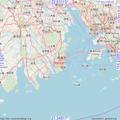
Wanzai GPS coordinates[2]
22° 12' 5.976" North, 113° 31' 40.152" East
| Map corner | latitude | longitude |
|---|---|---|
| Upper-left | 22.85113°, | 112.8247° |
| Center: | 22.20166°, | 113.52782° |
| Lower-right: | 21.54917°, | 114.23095° |
| Map W x H: | 144.8×144.8 km | = 90×90mi |
| max Lat: | 53.31946° ⇑96.9% North |
| Wanzai: | 22.20166° |
| min Lat: | ⇓3.1% South 18.22056° |
| min Long | Wanzai | max Long |
| 75.07348° | 113.52782° | 134.28917° |
| W 45.8%⇐ | ⇒54.2% E |
Elevation
Elevation of Wanzai is 4 m = 13 ft, and this is 480.8 m = 1577 ft below average elevation for this country.
| Max E: |
5622 m = 18445 ft | 98.3% |
| Avg. | 484.8 m = 1591 ft | |
| Wanzai | 4 m = 13 ft | |
Min E: |
-3 m = -10 ft | 1.7% |
See also: China elevation on elevation.city.
Geographical zone
Wanzai is located in North Torrid zone (between Equator and Tropic of Cancer). Distance of this Northern Tropic circle is 137.3 km =85.3 mi to North.| Distance of | km | miles | from Wanzai |
|---|---|---|---|
| North Pole | 7538.5 | 4684.2 | to North |
| Arctic Circle | 4932.6 | 3065 | to North |
| Tropic Cancer | 137.3 | 85.3 | to North |
| Equator | 2468.6 | 1533.9 | to South |


Nearby cities:
15 places around Wanzai: (largest is in red/bold)
• Banfu
31.6 km =19.6 mi,  317°
317°
• Hongqi
20 km =12.4 mi,  252°
252°
• Jida
7.3 km =4.5 mi,  36°
36°
• Jing’an
24.3 km =15.1 mi,  272°
272°
• Nanlang
32.3 km =20.1 mi,  1°
1°
• Nanping
4.1 km =2.5 mi,  310°
310°
• Qianshan
4.7 km =2.9 mi,  351°
351°
• Qianwu
30.9 km =19.2 mi,  262°
262°
• Sanxiang
19.9 km =12.4 mi,  326°
326°
• Sanzao
25.2 km =15.7 mi,  229°
229°
• Shenwan
19.1 km =11.9 mi,  301°
301°
• Tangjiawan
19 km =11.8 mi,  21°
21°
• Tanzhou
8.6 km =5.3 mi, 313°
• Wuguishan
24.8 km =15.4 mi,  335°
335°
• Zhuhai
9.3 km =5.8 mi,  26°
26°
Sources, notices
• [Note1] Compared only with cities in China existing in our database
• [Src1] Map data: © OpenStreetMap contributors (CC-BY-SA)
• [Src2] Other city data from geonames.org with taken over terms of usage.
• [Src3] Geographical zone / Annual Mean Temperature by Robert A. Rohde @ Wikipedia
