Shenwan geodata
Shenwan (Guangdong) is a seat of a fourth-order administrative division; located in China in Asia/Shanghai (GMT+8) time zone. In our database, there are 1268 cities with bigger population. Compared to other cities in China, 96.8% of cities are located further ↑North; 55.2% of cities are located further →East and 55.7% of cities have higher elevation than Shenwan. Note1


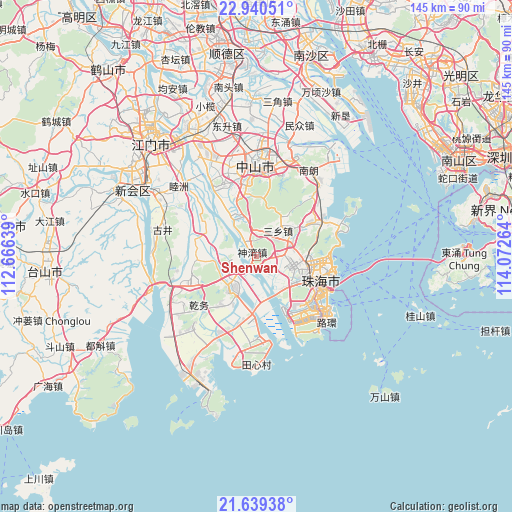
Shenwan GPS coordinates[2]
22° 17' 29.256" North, 113° 22' 10.236" East
| Map corner | latitude | longitude |
|---|---|---|
| Upper-left | 22.94051°, | 112.66639° |
| Center: | 22.29146°, | 113.36951° |
| Lower-right: | 21.63938°, | 114.07264° |
| Map W x H: | 144.7×144.7 km | = 89.9×89.9mi |
| max Lat: | 53.31946° ⇑96.8% North |
| Shenwan: | 22.29146° |
| min Lat: | ⇓3.2% South 18.22056° |
| min Long | Shenwan | max Long |
| 75.07348° | 113.36951° | 134.28917° |
| W 44.8%⇐ | ⇒55.2% E |
Elevation
Elevation of Shenwan is 126 m = 413 ft, and this is 358.8 m = 1177 ft below average elevation for this country.
| Max E: |
5622 m = 18445 ft | 55.7% |
| Avg. | 484.8 m = 1591 ft | |
| Shenwan | 126 m = 413 ft | |
Min E: |
-3 m = -10 ft | 44.3% |
See also: China elevation on elevation.city.
Geographical zone
Shenwan is located in North Torrid zone (between Equator and Tropic of Cancer). Distance of this Northern Tropic circle is 127.3 km =79.1 mi to North.| Distance of | km | miles | from Shenwan |
|---|---|---|---|
| North Pole | 7528.5 | 4678 | to North |
| Arctic Circle | 4922.6 | 3058.8 | to North |
| Tropic Cancer | 127.3 | 79.1 | to North |
| Equator | 2478.6 | 1540.1 | to South |


Nearby cities:
15 places around Shenwan: (largest is in red/bold)
• Banfu
14.2 km =8.8 mi,  338°
338°
• Doumen
19.4 km =12.1 mi,  250°
250°
• Hongqi
16.2 km =10.1 mi,  189°
189°
• Huancheng
20.1 km =12.5 mi,  0°
0°
• Jida
21.1 km =13.1 mi,  101°
101°
• Jing’an
12 km =7.5 mi,  221°
221°
• Lianzhou
17 km =10.6 mi,  280°
280°
• Nanping
15 km =9.3 mi,  119°
119°
• Qianshan
16.5 km =10.3 mi,  108°
108°
• Qianwu
20.1 km =12.5 mi,  225°
225°
• Sanxiang
8.4 km =5.2 mi,  38°
38°
• Tanzhou
10.8 km =6.7 mi, 112°
• Wanzai
19.1 km =11.9 mi, 121°
• Wuguishan
14 km =8.7 mi,  26°
26°
• Zhuhai
20.5 km =12.7 mi,  94°
94°
Sources, notices
• [Note1] Compared only with cities in China existing in our database
• [Src1] Map data: © OpenStreetMap contributors (CC-BY-SA)
• [Src2] Other city data from geonames.org with taken over terms of usage.
• [Src3] Geographical zone / Annual Mean Temperature by Robert A. Rohde @ Wikipedia
