Xiaguan geodata
Xiaguan (Zhejiang) is a seat of a fourth-order administrative division; located in China in Asia/Shanghai (GMT+8) time zone. In our database, there are 1268 cities with bigger population. Compared to other cities in China, 55.8% of cities are located further ↑North; 87.9% of cities are located further ←West and 64.3% of cities have higher elevation than Xiaguan. Note1


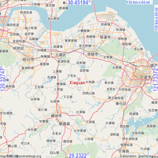
Xiaguan GPS coordinates[2]
29° 50' 38.148" North, 121° 1' 50.124" East
| Map corner | latitude | longitude |
|---|---|---|
| Upper-left | 30.45194°, | 120.32747° |
| Center: | 29.84393°, | 121.03059° |
| Lower-right: | 29.2322°, | 121.73372° |
| Map W x H: | 135.6×135.6 km | = 84.3×84.3mi |
| max Lat: | 53.31946° ⇑55.8% North |
| Xiaguan: | 29.84393° |
| min Lat: | ⇓44.2% South 18.22056° |
| min Long | Xiaguan | max Long |
| 75.07348° | 121.03059° | 134.28917° |
| W 87.9%⇐ | ⇒12.1% E |
Elevation
Elevation of Xiaguan is 76 m = 249 ft, and this is 408.8 m = 1341 ft below average elevation for this country.
| Max E: |
5622 m = 18445 ft | 64.3% |
| Avg. | 484.8 m = 1591 ft | |
| Xiaguan | 76 m = 249 ft | |
Min E: |
-3 m = -10 ft | 35.7% |
See also: China elevation on elevation.city.
Geographical zone
Xiaguan is located in North temperate zone (between Tropic of Cancer and the Arctic Circle). Distance of this Northern Tropic circle is 712.4 km =442.7 mi to South.| Distance of | km | miles | from Xiaguan |
|---|---|---|---|
| North Pole | 6688.7 | 4156.2 | to North |
| Arctic Circle | 4082.8 | 2536.9 | to North |
| Tropic Cancer | 712.4 | 442.7 | to South |
| Equator | 3318.3 | 2061.9 | to South |


Nearby cities:
15 places around Xiaguan: (largest is in red/bold)
• Chenxikou
3.6 km =2.2 mi,  144°
144°
• Fenghui
12.8 km =8 mi,  336°
336°
• Haoba
21.5 km =13.4 mi,  305°
305°
• Lianghu
20.8 km =12.9 mi,  322°
322°
• Liangnong
8.8 km =5.5 mi,  29°
29°
• Lubu
25.2 km =15.7 mi,  49°
49°
• Ruanzhuang
7.1 km =4.4 mi,  181°
181°
• Sanjie
20 km =12.4 mi,  241°
241°
• Shangpu
20.5 km =12.7 mi,  290°
290°
• Shangyu
24.5 km =15.2 mi, 321°
• Simingshan
14.3 km =8.9 mi,  147°
147°
• Tangpu
23.9 km =14.9 mi,  274°
274°
• Xiaodong
22.1 km =13.7 mi,  17°
17°
• Yongheshi
14.4 km =8.9 mi,  5°
5°
• Zhangzhen
16.1 km =10 mi,  256°
256°
Sources, notices
• [Note1] Compared only with cities in China existing in our database
• [Src1] Map data: © OpenStreetMap contributors (CC-BY-SA)
• [Src2] Other city data from geonames.org with taken over terms of usage.
• [Src3] Geographical zone / Annual Mean Temperature by Robert A. Rohde @ Wikipedia
