Wuzhou geodata
Wuzhou (Guangxi) is a seat of a second-order administrative division; located in China in Asia/Shanghai (GMT+8) time zone. With population of 265,846 people, there are 188 cities with bigger population in this country. Compared to other cities in China, 92.3% of cities are located further ↑North; 65.8% of cities are located further →East and 64.5% of cities have higher elevation than Wuzhou. Note1


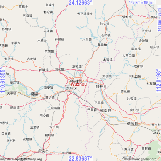
Wuzhou GPS coordinates[2]
23° 28' 59.988" North, 111° 19' 0.012" East
| Map corner | latitude | longitude |
|---|---|---|
| Upper-left | 24.12663°, | 110.61355° |
| Center: | 23.48333°, | 111.31667° |
| Lower-right: | 22.83687°, | 112.0198° |
| Map W x H: | 143.4×143.4 km | = 89.1×89.1mi |
| max Lat: | 53.31946° ⇑92.3% North |
| Wuzhou: | 23.48333° |
| min Lat: | ⇓7.7% South 18.22056° |
| min Long | Wuzhou | max Long |
| 75.07348° | 111.31667° | 134.28917° |
| W 34.2%⇐ | ⇒65.8% E |
Elevation
Elevation of Wuzhou is 75 m = 246 ft, and this is 409.8 m = 1344 ft below average elevation for this country.
| Max E: |
5622 m = 18445 ft | 64.5% |
| Avg. | 484.8 m = 1591 ft | |
| Wuzhou | 75 m = 246 ft | |
Min E: |
-3 m = -10 ft | 35.5% |
See also: Wuzhou elevation on elevation.city.
Geographical zone
Wuzhou is located in North temperate zone (between Tropic of Cancer and the Arctic Circle). Distance of this Northern Tropic circle is 5.2 km =3.2 mi to South.| Distance of | km | miles | from Wuzhou |
|---|---|---|---|
| North Pole | 7396 | 4595.7 | to North |
| Arctic Circle | 4790.1 | 2976.4 | to North |
| Tropic Cancer | 5.2 | 3.2 | to South |
| Equator | 2611.1 | 1622.5 | to South |


Nearby cities:
15 places around Wuzhou: (largest is in red/bold)
• Baigou
32.5 km =20.2 mi,  85°
85°
• Changgang
35.2 km =21.9 mi,  130°
130°
• Dazhou
23 km =14.3 mi,  80°
80°
• Ducheng
34.4 km =21.4 mi,  141°
141°
• Duping
41.6 km =25.8 mi,  65°
65°
• Guixu
39.6 km =24.6 mi,  158°
158°
• Jiancheng
44.7 km =27.8 mi,  149°
149°
• Jiangchuan
18.1 km =11.2 mi,  119°
119°
• Jiangkou
19.1 km =11.9 mi,  104°
104°
• Longxu
11.3 km =7 mi,  228°
228°
• Luodong
32.6 km =20.3 mi,  110°
110°
• Pingfeng
25.4 km =15.8 mi, 142°
• Pingtai
27.8 km =17.3 mi, 158°
• Xinghua
41.8 km =26 mi, 102°
• Yulao
42.9 km =26.7 mi, 87°
Sources, notices
• [Note1] Compared only with cities in China existing in our database
• [Src1] Map data: © OpenStreetMap contributors (CC-BY-SA)
• [Src2] Other city data from geonames.org with taken over terms of usage.
• [Src3] Geographical zone / Annual Mean Temperature by Robert A. Rohde @ Wikipedia
