Duping geodata
Duping (Guangdong) is a seat of a fourth-order administrative division; located in China in Asia/Shanghai (GMT+8) time zone. In our database, there are 1268 cities with bigger population. Compared to other cities in China, 91.6% of cities are located further ↑North; 64.1% of cities are located further →East and 69.2% of cities have higher elevation than Duping. Note1


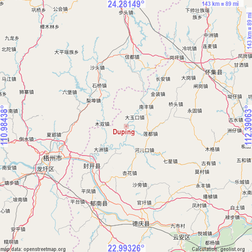
Duping GPS coordinates[2]
23° 38' 20.256" North, 111° 41' 15" East
| Map corner | latitude | longitude |
|---|---|---|
| Upper-left | 24.28149°, | 110.98438° |
| Center: | 23.63896°, | 111.6875° |
| Lower-right: | 22.99326°, | 112.39063° |
| Map W x H: | 143.2×143.2 km | = 89×89mi |
| max Lat: | 53.31946° ⇑91.6% North |
| Duping: | 23.63896° |
| min Lat: | ⇓8.4% South 18.22056° |
| min Long | Duping | max Long |
| 75.07348° | 111.6875° | 134.28917° |
| W 35.9%⇐ | ⇒64.1% E |
Elevation
Elevation of Duping is 55 m = 180 ft, and this is 429.8 m = 1410 ft below average elevation for this country.
| Max E: |
5622 m = 18445 ft | 69.2% |
| Avg. | 484.8 m = 1591 ft | |
| Duping | 55 m = 180 ft | |
Min E: |
-3 m = -10 ft | 30.8% |
See also: China elevation on elevation.city.
Geographical zone
Duping is located in North temperate zone (between Tropic of Cancer and the Arctic Circle). Distance of this Northern Tropic circle is 22.5 km =14 mi to South.| Distance of | km | miles | from Duping |
|---|---|---|---|
| North Pole | 7378.7 | 4584.9 | to North |
| Arctic Circle | 4772.8 | 2965.7 | to North |
| Tropic Cancer | 22.5 | 14 | to South |
| Equator | 2628.4 | 1633.2 | to South |


Nearby cities:
15 places around Duping: (largest is in red/bold)
• Baigou
15.7 km =9.8 mi,  200°
200°
• Chang’an
34.2 km =21.3 mi,  37°
37°
• Dayukou
7.1 km =4.4 mi, 43°
• Dazhou
20.3 km =12.6 mi,  228°
228°
• He’erkou
17.5 km =10.9 mi,  145°
145°
• Jiangchuan
34.1 km =21.2 mi,  220°
220°
• Jiangkou
29.5 km =18.3 mi, 221°
• Jinzhuang
25.6 km =15.9 mi,  45°
45°
• Liandu
14.6 km =9.1 mi,  111°
111°
• Luodong
29.6 km =18.4 mi,  194°
194°
• Nanfeng
14.9 km =9.3 mi, 48°
• Qiaotou
31.1 km =19.3 mi,  67°
67°
• Shidong
38.7 km =24 mi,  93°
93°
• Xinghua
26.7 km =16.6 mi,  173°
173°
• Yulao
16.6 km =10.3 mi,  162°
162°
Sources, notices
• [Note1] Compared only with cities in China existing in our database
• [Src1] Map data: © OpenStreetMap contributors (CC-BY-SA)
• [Src2] Other city data from geonames.org with taken over terms of usage.
• [Src3] Geographical zone / Annual Mean Temperature by Robert A. Rohde @ Wikipedia
