Wushi geodata
Wushi (Guangdong) is a seat of a fourth-order administrative division; located in China in Asia/Shanghai (GMT+8) time zone. In our database, there are 1268 cities with bigger population. Compared to other cities in China, 88.2% of cities are located further ↑North; 53.7% of cities are located further →East and 67.8% of cities have higher elevation than Wushi. Note1


Wushi GPS coordinates[2]
24° 34' 28.38" North, 113° 35' 44.304" East
| Map corner | latitude | longitude |
|---|---|---|
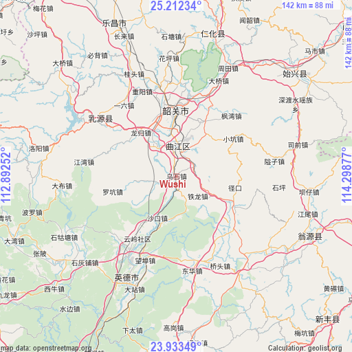
| Upper-left | 25.21234°, | 112.89252° |
| Center: | 24.57455°, | 113.59564° |
| Lower-right: | 23.93349°, | 114.29877° |
| Map W x H: | 142.2×142.2 km | = 88.4×88.4mi |
| max Lat: | 53.31946° ⇑88.2% North |
| Wushi: | 24.57455° |
| min Lat: | ⇓11.8% South 18.22056° |
| min Long | Wushi | max Long |
| 75.07348° | 113.59564° | 134.28917° |
| W 46.3%⇐ | ⇒53.7% E |
Elevation
Elevation of Wushi is 61 m = 200 ft, and this is 423.8 m = 1390 ft below average elevation for this country.
| Max E: |
5622 m = 18445 ft | 67.8% |
| Avg. | 484.8 m = 1591 ft | |
| Wushi | 61 m = 200 ft | |
Min E: |
-3 m = -10 ft | 32.2% |
See also: China elevation on elevation.city.
Geographical zone
Wushi is located in North temperate zone (between Tropic of Cancer and the Arctic Circle). Distance of this Northern Tropic circle is 126.5 km =78.6 mi to South.| Distance of | km | miles | from Wushi |
|---|---|---|---|
| North Pole | 7274.6 | 4520.2 | to North |
| Arctic Circle | 4668.7 | 2901 | to North |
| Tropic Cancer | 126.5 | 78.6 | to South |
| Equator | 2732.4 | 1697.8 | to South |


Nearby cities:
15 places around Wushi: (largest is in red/bold)
• Baitu
14.6 km =9.1 mi,  325°
325°
• Datang
24.3 km =15.1 mi,  23°
23°
• Leyuan
20.2 km =12.6 mi,  356°
356°
• Longgui
23.2 km =14.4 mi,  320°
320°
• Luokeng
27 km =16.8 mi,  256°
256°
• Maba
12.2 km =7.6 mi,  1°
1°
• Shakou
18.3 km =11.4 mi,  206°
206°
• Shaoguan
25.1 km =15.6 mi, 357°
• Shaxi
8.9 km =5.5 mi,  58°
58°
• Tielong
11.8 km =7.3 mi,  133°
133°
• Xiaokeng
27.2 km =16.9 mi,  54°
54°
• Xihe
25.7 km =16 mi,  352°
352°
• Xilian
21.6 km =13.4 mi,  343°
343°
• Xinjiang
26.5 km =16.5 mi,  116°
116°
• Zhangshi
8.7 km =5.4 mi,  248°
248°
Sources, notices
• [Note1] Compared only with cities in China existing in our database
• [Src1] Map data: © OpenStreetMap contributors (CC-BY-SA)
• [Src2] Other city data from geonames.org with taken over terms of usage.
• [Src3] Geographical zone / Annual Mean Temperature by Robert A. Rohde @ Wikipedia
