Maba geodata
Maba (Guangdong) is a seat of a third-order administrative division; located in China in Asia/Shanghai (GMT+8) time zone. With population of 113,609 people, there are 384 cities with bigger population in this country. Compared to other cities in China, 87.7% of cities are located further ↑North; 53.7% of cities are located further →East and 66.1% of cities have higher elevation than Maba. Note1


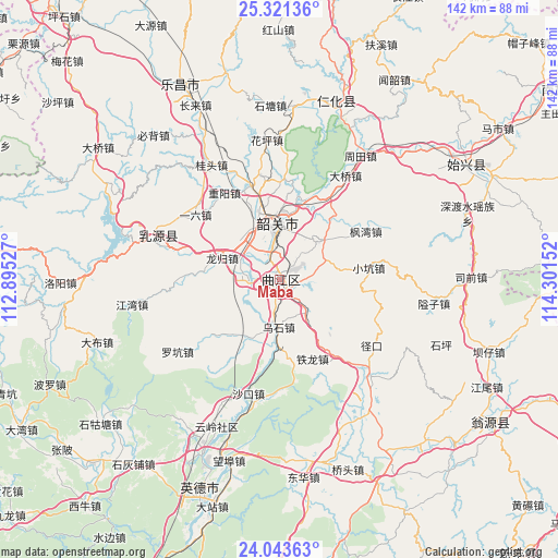
Maba GPS coordinates[2]
24° 41' 2.868" North, 113° 35' 54.204" East
| Map corner | latitude | longitude |
|---|---|---|
| Upper-left | 25.32136°, | 112.89527° |
| Center: | 24.68413°, | 113.59839° |
| Lower-right: | 24.04363°, | 114.30152° |
| Map W x H: | 142.1×142.1 km | = 88.3×88.3mi |
| max Lat: | 53.31946° ⇑87.7% North |
| Maba: | 24.68413° |
| min Lat: | ⇓12.3% South 18.22056° |
| min Long | Maba | max Long |
| 75.07348° | 113.59839° | 134.28917° |
| W 46.3%⇐ | ⇒53.7% E |
Elevation
Elevation of Maba is 68 m = 223 ft, and this is 416.8 m = 1367 ft below average elevation for this country.
| Max E: |
5622 m = 18445 ft | 66.1% |
| Avg. | 484.8 m = 1591 ft | |
| Maba | 68 m = 223 ft | |
Min E: |
-3 m = -10 ft | 33.9% |
See also: Maba elevation on elevation.city.
Geographical zone
Maba is located in North temperate zone (between Tropic of Cancer and the Arctic Circle). Distance of this Northern Tropic circle is 138.7 km =86.2 mi to South.| Distance of | km | miles | from Maba |
|---|---|---|---|
| North Pole | 7262.4 | 4512.6 | to North |
| Arctic Circle | 4656.6 | 2893.5 | to North |
| Tropic Cancer | 138.7 | 86.2 | to South |
| Equator | 2744.6 | 1705.4 | to South |


Nearby cities:
15 places around Maba: (largest is in red/bold)
• Baitu
8.5 km =5.3 mi,  269°
269°
• Datang
13.9 km =8.6 mi,  43°
43°
• Fengwan
24.9 km =15.5 mi,  58°
58°
• Leyuan
8.1 km =5 mi,  348°
348°
• Longgui
16.1 km =10 mi,  290°
290°
• Shaoguan
13 km =8.1 mi, 353°
• Shaxi
10.4 km =6.5 mi,  135°
135°
• Shiliting
18.5 km =11.5 mi, 349°
• Tielong
21.9 km =13.6 mi,  157°
157°
• Wushi
12.2 km =7.6 mi,  181°
181°
• Xiaokeng
22.1 km =13.7 mi,  80°
80°
• Xihe
13.8 km =8.6 mi,  344°
344°
• Xilian
10.6 km =6.6 mi,  323°
323°
• Xinshao
15.4 km =9.6 mi,  2°
2°
• Zhangshi
17.5 km =10.9 mi,  208°
208°
Sources, notices
• [Note1] Compared only with cities in China existing in our database
• [Src1] Map data: © OpenStreetMap contributors (CC-BY-SA)
• [Src2] Other city data from geonames.org with taken over terms of usage.
• [Src3] Geographical zone / Annual Mean Temperature by Robert A. Rohde @ Wikipedia
