Tielong geodata
Tielong (Guangdong) is a seat of a fourth-order administrative division; located in China in Asia/Shanghai (GMT+8) time zone. In our database, there are 1268 cities with bigger population. Compared to other cities in China, 88.5% of cities are located further ↑North; 53.2% of cities are located further →East and 55.3% of cities have lower elevation than Tielong. Note1


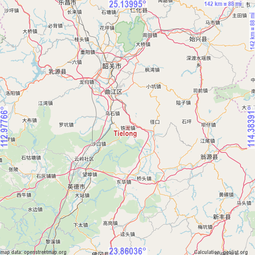
Tielong GPS coordinates[2]
24° 30' 6.408" North, 113° 40' 50.808" East
| Map corner | latitude | longitude |
|---|---|---|
| Upper-left | 25.13995°, | 112.97766° |
| Center: | 24.50178°, | 113.68078° |
| Lower-right: | 23.86036°, | 114.38391° |
| Map W x H: | 142.3×142.3 km | = 88.4×88.4mi |
| max Lat: | 53.31946° ⇑88.5% North |
| Tielong: | 24.50178° |
| min Lat: | ⇓11.5% South 18.22056° |
| min Long | Tielong | max Long |
| 75.07348° | 113.68078° | 134.28917° |
| W 46.8%⇐ | ⇒53.2% E |
Elevation
Elevation of Tielong is 209 m = 686 ft, and this is 275.8 m = 905 ft below average elevation for this country.
| Max E: |
5622 m = 18445 ft | 44.7% |
| Avg. | 484.8 m = 1591 ft | |
| Tielong | 209 m = 686 ft | |
Min E: |
-3 m = -10 ft | 55.3% |
See also: China elevation on elevation.city.
Geographical zone
Tielong is located in North temperate zone (between Tropic of Cancer and the Arctic Circle). Distance of this Northern Tropic circle is 118.4 km =73.6 mi to South.| Distance of | km | miles | from Tielong |
|---|---|---|---|
| North Pole | 7282.7 | 4525.3 | to North |
| Arctic Circle | 4676.8 | 2906 | to North |
| Tropic Cancer | 118.4 | 73.6 | to South |
| Equator | 2724.3 | 1692.8 | to South |


Nearby cities:
15 places around Tielong: (largest is in red/bold)
• Baitu
26.2 km =16.3 mi,  320°
320°
• Donghua
30.1 km =18.7 mi,  182°
182°
• Hengshishui
20.3 km =12.6 mi,  143°
143°
• Hongling
28.2 km =17.5 mi,  96°
96°
• Leyuan
29.9 km =18.6 mi,  340°
340°
• Maba
21.9 km =13.6 mi, 337°
• Qiaotou
29.1 km =18.1 mi,  161°
161°
• Shakou
18.7 km =11.6 mi,  243°
243°
• Shaxi
12.8 km =8 mi,  355°
355°
• Wengcheng
20.3 km =12.6 mi,  133°
133°
• Wushi
11.8 km =7.3 mi,  313°
313°
• Xiaokeng
27.5 km =17.1 mi,  29°
29°
• Xinjiang
15.6 km =9.7 mi, 103°
• Yunling
29.9 km =18.6 mi,  234°
234°
• Zhangshi
17.4 km =10.8 mi,  286°
286°
Sources, notices
• [Note1] Compared only with cities in China existing in our database
• [Src1] Map data: © OpenStreetMap contributors (CC-BY-SA)
• [Src2] Other city data from geonames.org with taken over terms of usage.
• [Src3] Geographical zone / Annual Mean Temperature by Robert A. Rohde @ Wikipedia
