Leyuan geodata
Leyuan (Guangdong) is a seat of a fourth-order administrative division; located in China in Asia/Shanghai (GMT+8) time zone. In our database, there are 1268 cities with bigger population. Compared to other cities in China, 87.4% of cities are located further ↑North; 53.8% of cities are located further →East and 68% of cities have higher elevation than Leyuan. Note1


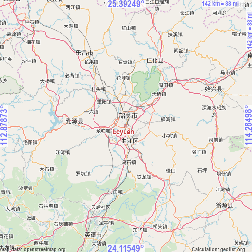
Leyuan GPS coordinates[2]
24° 45' 20.268" North, 113° 34' 54.66" East
| Map corner | latitude | longitude |
|---|---|---|
| Upper-left | 25.39249°, | 112.87873° |
| Center: | 24.75563°, | 113.58185° |
| Lower-right: | 24.11549°, | 114.28498° |
| Map W x H: | 142×142 km | = 88.2×88.2mi |
| max Lat: | 53.31946° ⇑87.4% North |
| Leyuan: | 24.75563° |
| min Lat: | ⇓12.6% South 18.22056° |
| min Long | Leyuan | max Long |
| 75.07348° | 113.58185° | 134.28917° |
| W 46.2%⇐ | ⇒53.8% E |
Elevation
Elevation of Leyuan is 60 m = 197 ft, and this is 424.8 m = 1394 ft below average elevation for this country.
| Max E: |
5622 m = 18445 ft | 68% |
| Avg. | 484.8 m = 1591 ft | |
| Leyuan | 60 m = 197 ft | |
Min E: |
-3 m = -10 ft | 32% |
See also: China elevation on elevation.city.
Geographical zone
Leyuan is located in North temperate zone (between Tropic of Cancer and the Arctic Circle). Distance of this Northern Tropic circle is 146.6 km =91.1 mi to South.| Distance of | km | miles | from Leyuan |
|---|---|---|---|
| North Pole | 7254.5 | 4507.7 | to North |
| Arctic Circle | 4648.6 | 2888.5 | to North |
| Tropic Cancer | 146.6 | 91.1 | to South |
| Equator | 2752.6 | 1710.4 | to South |


Nearby cities:
15 places around Leyuan: (largest is in red/bold)
• Baitu
10.6 km =6.6 mi,  220°
220°
• Datang
11.4 km =7.1 mi,  79°
79°
• Fengwan
23.5 km =14.6 mi, 77°
• Lishi
17.2 km =10.7 mi,  340°
340°
• Longgui
13.7 km =8.5 mi,  260°
260°
• Maba
8.1 km =5 mi,  168°
168°
• Shaoguan
4.9 km =3 mi,  1°
1°
• Shaxi
17.8 km =11.1 mi,  149°
149°
• Shiliting
10.4 km =6.5 mi,  350°
350°
• Wushi
20.2 km =12.6 mi,  176°
176°
• Xihe
5.7 km =3.5 mi, 338°
• Xilian
4.7 km =2.9 mi,  277°
277°
• Xinshao
7.8 km =4.8 mi,  18°
18°
• Yiliu
20 km =12.4 mi,  296°
296°
• Zhongyang
18.9 km =11.7 mi,  319°
319°
Sources, notices
• [Note1] Compared only with cities in China existing in our database
• [Src1] Map data: © OpenStreetMap contributors (CC-BY-SA)
• [Src2] Other city data from geonames.org with taken over terms of usage.
• [Src3] Geographical zone / Annual Mean Temperature by Robert A. Rohde @ Wikipedia
