Huangtianfan geodata
Huangtianfan (Zhejiang) is a seat of a fourth-order administrative division; located in China in Asia/Shanghai (GMT+8) time zone. In our database, there are 1268 cities with bigger population. Compared to other cities in China, 63.6% of cities are located further ↑North; 82.8% of cities are located further ←West and 62.9% of cities have higher elevation than Huangtianfan. Note1


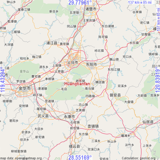
Huangtianfan GPS coordinates[2]
29° 10' 2.964" North, 120° 8' 9.816" East
| Map corner | latitude | longitude |
|---|---|---|
| Upper-left | 29.77961°, | 119.43294° |
| Center: | 29.16749°, | 120.13606° |
| Lower-right: | 28.55169°, | 120.83919° |
| Map W x H: | 136.5×136.5 km | = 84.8×84.8mi |
| max Lat: | 53.31946° ⇑63.6% North |
| Huangtianfan: | 29.16749° |
| min Lat: | ⇓36.4% South 18.22056° |
| min Long | Huangtianfan | max Long |
| 75.07348° | 120.13606° | 134.28917° |
| W 82.8%⇐ | ⇒17.2% E |
Elevation
Elevation of Huangtianfan is 83 m = 272 ft, and this is 401.8 m = 1318 ft below average elevation for this country.
| Max E: |
5622 m = 18445 ft | 62.9% |
| Avg. | 484.8 m = 1591 ft | |
| Huangtianfan | 83 m = 272 ft | |
Min E: |
-3 m = -10 ft | 37.1% |
See also: China elevation on elevation.city.
Geographical zone
Huangtianfan is located in North temperate zone (between Tropic of Cancer and the Arctic Circle). Distance of this Northern Tropic circle is 637.2 km =395.9 mi to South.| Distance of | km | miles | from Huangtianfan |
|---|---|---|---|
| North Pole | 6763.9 | 4202.9 | to North |
| Arctic Circle | 4158.1 | 2583.7 | to North |
| Tropic Cancer | 637.2 | 395.9 | to South |
| Equator | 3243.1 | 2015.2 | to South |


Nearby cities:
15 places around Huangtianfan: (largest is in red/bold)
• Chi’an
10.6 km =6.6 mi,  256°
256°
• Choujiang
16.6 km =10.3 mi,  320°
320°
• Dongyang
14.1 km =8.8 mi,  37°
37°
• Fangjun
15 km =9.3 mi,  135°
135°
• Hengdian
17.4 km =10.8 mi,  93°
93°
• Huaxi
3.8 km =2.4 mi, 36°
• Jiangbei
17.5 km =10.9 mi,  32°
32°
• Longshan
16.7 km =10.4 mi,  164°
164°
• Maodian
15.7 km =9.8 mi,  241°
241°
• Nanshi
9.3 km =5.8 mi,  102°
102°
• Quanfu
10.8 km =6.7 mi,  130°
130°
• Wuning
13.7 km =8.5 mi, 42°
• Xiangzhu
20.5 km =12.7 mi,  195°
195°
• Yiting
18.6 km =11.6 mi,  294°
294°
• Yiwu
17.4 km =10.8 mi,  340°
340°
Sources, notices
• [Note1] Compared only with cities in China existing in our database
• [Src1] Map data: © OpenStreetMap contributors (CC-BY-SA)
• [Src2] Other city data from geonames.org with taken over terms of usage.
• [Src3] Geographical zone / Annual Mean Temperature by Robert A. Rohde @ Wikipedia
