Sancha geodata
Sancha (Hubei) is a seat of a fourth-order administrative division; located in China in Asia/Shanghai (GMT+8) time zone. In our database, there are 1268 cities with bigger population. Compared to other cities in China, 54.4% of cities are located further ↓South; 51% of cities are located further →East and 78.8% of cities have higher elevation than Sancha. Note1


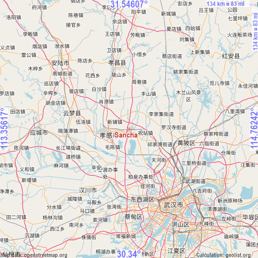
Sancha GPS coordinates[2]
30° 56' 41.784" North, 114° 3' 33.444" East
| Map corner | latitude | longitude |
|---|---|---|
| Upper-left | 31.54607°, | 113.35617° |
| Center: | 30.94494°, | 114.05929° |
| Lower-right: | 30.34°, | 114.76242° |
| Map W x H: | 134.1×134.1 km | = 83.3×83.3mi |
| max Lat: | 53.31946° ⇑45.6% North |
| Sancha: | 30.94494° |
| min Lat: | ⇓54.4% South 18.22056° |
| min Long | Sancha | max Long |
| 75.07348° | 114.05929° | 134.28917° |
| W 49%⇐ | ⇒51% E |
Elevation
Elevation of Sancha is 29 m = 95 ft, and this is 455.8 m = 1495 ft below average elevation for this country.
| Max E: |
5622 m = 18445 ft | 78.8% |
| Avg. | 484.8 m = 1591 ft | |
| Sancha | 29 m = 95 ft | |
Min E: |
-3 m = -10 ft | 21.2% |
See also: China elevation on elevation.city.
Geographical zone
Sancha is located in North temperate zone (between Tropic of Cancer and the Arctic Circle). Distance of this Northern Tropic circle is 834.8 km =518.7 mi to South.| Distance of | km | miles | from Sancha |
|---|---|---|---|
| North Pole | 6566.3 | 4080.1 | to North |
| Arctic Circle | 3960.4 | 2460.9 | to North |
| Tropic Cancer | 834.8 | 518.7 | to South |
| Equator | 3440.8 | 2138 | to South |


Nearby cities:
15 places around Sancha: (largest is in red/bold)
• Chezhan
13.2 km =8.2 mi,  273°
273°
• Guangchang
14.1 km =8.8 mi,  260°
260°
• Lijiaji
18.6 km =11.6 mi,  63°
63°
• Maochen
12.5 km =7.8 mi,  224°
224°
• Minji
13.4 km =8.3 mi,  149°
149°
• Pengxing
14.2 km =8.8 mi,  279°
279°
• Shuyuan
15.4 km =9.6 mi, 260°
• Wolong
16.2 km =10.1 mi,  254°
254°
• Xiaogan
13.2 km =8.2 mi, 261°
• Xihe
8.5 km =5.3 mi,  326°
326°
• Xinhua
14.7 km =9.1 mi, 256°
• Xinpu
8.6 km =5.3 mi,  298°
298°
• Yangdian
10.2 km =6.3 mi,  26°
26°
• Zhuzhan
9.4 km =5.8 mi,  102°
102°
• Zougang
15.8 km =9.8 mi,  349°
349°
Sources, notices
• [Note1] Compared only with cities in China existing in our database
• [Src1] Map data: © OpenStreetMap contributors (CC-BY-SA)
• [Src2] Other city data from geonames.org with taken over terms of usage.
• [Src3] Geographical zone / Annual Mean Temperature by Robert A. Rohde @ Wikipedia
