Maochen geodata
Maochen (Hubei) is a seat of a fourth-order administrative division; located in China in Asia/Shanghai (GMT+8) time zone. In our database, there are 1268 cities with bigger population. Compared to other cities in China, 53.5% of cities are located further ↓South; 51.6% of cities are located further →East and 76.2% of cities have higher elevation than Maochen. Note1


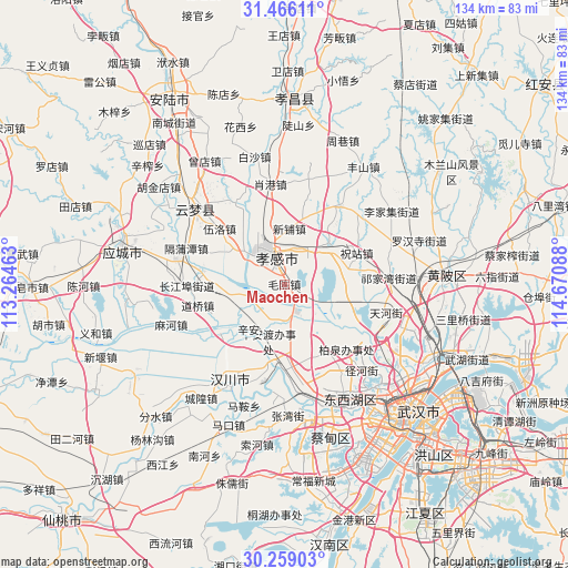
Maochen GPS coordinates[2]
30° 51' 52.092" North, 113° 58' 3.9" East
| Map corner | latitude | longitude |
|---|---|---|
| Upper-left | 31.46611°, | 113.26463° |
| Center: | 30.86447°, | 113.96775° |
| Lower-right: | 30.25903°, | 114.67088° |
| Map W x H: | 134.2×134.2 km | = 83.4×83.4mi |
| max Lat: | 53.31946° ⇑46.5% North |
| Maochen: | 30.86447° |
| min Lat: | ⇓53.5% South 18.22056° |
| min Long | Maochen | max Long |
| 75.07348° | 113.96775° | 134.28917° |
| W 48.4%⇐ | ⇒51.6% E |
Elevation
Elevation of Maochen is 34 m = 112 ft, and this is 450.8 m = 1479 ft below average elevation for this country.
| Max E: |
5622 m = 18445 ft | 76.2% |
| Avg. | 484.8 m = 1591 ft | |
| Maochen | 34 m = 112 ft | |
Min E: |
-3 m = -10 ft | 23.8% |
See also: China elevation on elevation.city.
Geographical zone
Maochen is located in North temperate zone (between Tropic of Cancer and the Arctic Circle). Distance of this Northern Tropic circle is 825.9 km =513.2 mi to South.| Distance of | km | miles | from Maochen |
|---|---|---|---|
| North Pole | 6575.3 | 4085.7 | to North |
| Arctic Circle | 3969.4 | 2466.5 | to North |
| Tropic Cancer | 825.9 | 513.2 | to South |
| Equator | 3431.8 | 2132.4 | to South |


Nearby cities:
15 places around Maochen: (largest is in red/bold)
• Chezhan
10.6 km =6.6 mi,  335°
335°
• Dongshan
10.8 km =6.7 mi,  155°
155°
• Guangchang
8.5 km =5.3 mi,  322°
322°
• Minji
15.7 km =9.8 mi,  99°
99°
• Pengxing
12.4 km =7.7 mi,  334°
334°
• Sancha
12.5 km =7.8 mi,  44°
44°
• Shahe
15.9 km =9.9 mi,  299°
299°
• Shuyuan
9 km =5.6 mi,  314°
314°
• Wolong
8.3 km =5.2 mi, 303°
• Xiaogan
8.2 km =5.1 mi, 327°
• Xiaxindian
13 km =8.1 mi,  254°
254°
• Xihe
16.5 km =10.3 mi,  14°
14°
• Xinhua
7.9 km =4.9 mi, 315°
• Xinpu
13.2 km =8.2 mi, 5°
• Xin’andu
14 km =8.7 mi,  196°
196°
Sources, notices
• [Note1] Compared only with cities in China existing in our database
• [Src1] Map data: © OpenStreetMap contributors (CC-BY-SA)
• [Src2] Other city data from geonames.org with taken over terms of usage.
• [Src3] Geographical zone / Annual Mean Temperature by Robert A. Rohde @ Wikipedia
