Wentang geodata
Wentang (Jiangxi) is a seat of a fourth-order administrative division; located in China in Asia/Shanghai (GMT+8) time zone. In our database, there are 1268 cities with bigger population. Compared to other cities in China, 75.8% of cities are located further ↑North; 50.3% of cities are located further ←West and 51.7% of cities have lower elevation than Wentang. Note1


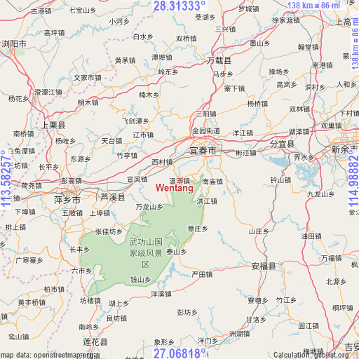
Wentang GPS coordinates[2]
27° 41' 33.108" North, 114° 17' 8.484" East
| Map corner | latitude | longitude |
|---|---|---|
| Upper-left | 28.31333°, | 113.58257° |
| Center: | 27.69253°, | 114.28569° |
| Lower-right: | 27.06818°, | 114.98882° |
| Map W x H: | 138.4×138.4 km | = 86×86mi |
| max Lat: | 53.31946° ⇑75.8% North |
| Wentang: | 27.69253° |
| min Lat: | ⇓24.2% South 18.22056° |
| min Long | Wentang | max Long |
| 75.07348° | 114.28569° | 134.28917° |
| W 50.3%⇐ | ⇒49.7% E |
Elevation
Elevation of Wentang is 179 m = 587 ft, and this is 305.8 m = 1003 ft below average elevation for this country.
| Max E: |
5622 m = 18445 ft | 48.3% |
| Avg. | 484.8 m = 1591 ft | |
| Wentang | 179 m = 587 ft | |
Min E: |
-3 m = -10 ft | 51.7% |
See also: China elevation on elevation.city.
Geographical zone
Wentang is located in North temperate zone (between Tropic of Cancer and the Arctic Circle). Distance of this Northern Tropic circle is 473.2 km =294 mi to South.| Distance of | km | miles | from Wentang |
|---|---|---|---|
| North Pole | 6927.9 | 4304.8 | to North |
| Arctic Circle | 4322.1 | 2685.6 | to North |
| Tropic Cancer | 473.2 | 294 | to South |
| Equator | 3079.1 | 1913.3 | to South |


Nearby cities:
15 places around Wentang: (largest is in red/bold)
• Chuntai
15.5 km =9.6 mi,  38°
38°
• Hongjiang
13.3 km =8.3 mi,  127°
127°
• Huayun
19.7 km =12.2 mi,  228°
228°
• Hutian
15.7 km =9.8 mi,  22°
22°
• Nanmiao
12.5 km =7.8 mi,  92°
92°
• Wanlongshan
15.4 km =9.6 mi, 228°
• Xiapu
19.3 km =12 mi,  53°
53°
• Xicun
9.6 km =6 mi,  316°
316°
• Xinfang
18.2 km =11.3 mi, 87°
• Xintian
15 km =9.3 mi,  349°
349°
• Xuanfeng
16.3 km =10.1 mi,  271°
271°
• Yichun
19.3 km =12 mi, 35°
• Yinhe
16.6 km =10.3 mi, 272°
• Yuanzhou
14.8 km =9.2 mi, 37°
• Zhangzhuang
19.8 km =12.3 mi,  158°
158°
Sources, notices
• [Note1] Compared only with cities in China existing in our database
• [Src1] Map data: © OpenStreetMap contributors (CC-BY-SA)
• [Src2] Other city data from geonames.org with taken over terms of usage.
• [Src3] Geographical zone / Annual Mean Temperature by Robert A. Rohde @ Wikipedia
