Xicun geodata
Xicun (Jiangxi) is a seat of a fourth-order administrative division; located in China in Asia/Shanghai (GMT+8) time zone. In our database, there are 1268 cities with bigger population. Compared to other cities in China, 75.5% of cities are located further ↑North; 50.1% of cities are located further →East and 58.9% of cities have higher elevation than Xicun. Note1


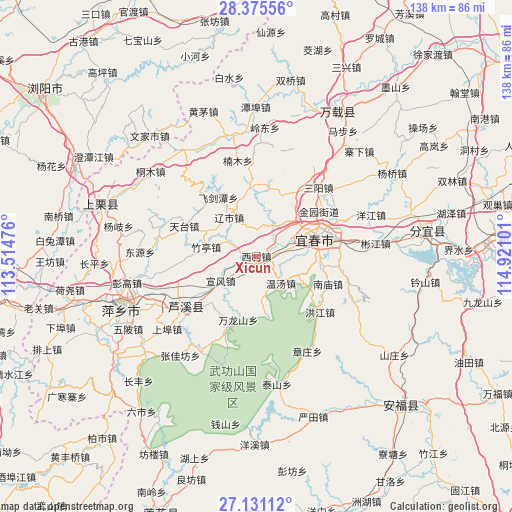
Xicun GPS coordinates[2]
27° 45' 18.432" North, 114° 13' 4.368" East
| Map corner | latitude | longitude |
|---|---|---|
| Upper-left | 28.37556°, | 113.51476° |
| Center: | 27.75512°, | 114.21788° |
| Lower-right: | 27.13112°, | 114.92101° |
| Map W x H: | 138.4×138.4 km | = 86×86mi |
| max Lat: | 53.31946° ⇑75.5% North |
| Xicun: | 27.75512° |
| min Lat: | ⇓24.5% South 18.22056° |
| min Long | Xicun | max Long |
| 75.07348° | 114.21788° | 134.28917° |
| W 49.9%⇐ | ⇒50.1% E |
Elevation
Elevation of Xicun is 105 m = 344 ft, and this is 379.8 m = 1246 ft below average elevation for this country.
| Max E: |
5622 m = 18445 ft | 58.9% |
| Avg. | 484.8 m = 1591 ft | |
| Xicun | 105 m = 344 ft | |
Min E: |
-3 m = -10 ft | 41.1% |
See also: China elevation on elevation.city.
Geographical zone
Xicun is located in North temperate zone (between Tropic of Cancer and the Arctic Circle). Distance of this Northern Tropic circle is 480.2 km =298.4 mi to South.| Distance of | km | miles | from Xicun |
|---|---|---|---|
| North Pole | 6921 | 4300.5 | to North |
| Arctic Circle | 4315.1 | 2681.3 | to North |
| Tropic Cancer | 480.2 | 298.4 | to South |
| Equator | 3086.1 | 1917.6 | to South |


Nearby cities:
15 places around Xicun: (largest is in red/bold)
• Chuntai
17.1 km =10.6 mi,  72°
72°
• Feijiantan
18.7 km =11.6 mi,  327°
327°
• Hongtang
18 km =11.2 mi,  22°
22°
• Hutian
14.8 km =9.2 mi,  59°
59°
• Jinrui
19.2 km =11.9 mi,  355°
355°
• Nanmiao
20.6 km =12.8 mi,  111°
111°
• Raoshi
12.9 km =8 mi, 325°
• Wanlongshan
17.8 km =11.1 mi,  196°
196°
• Wentang
9.6 km =6 mi,  136°
136°
• Xintian
8.7 km =5.4 mi,  26°
26°
• Xuanfeng
11.7 km =7.3 mi,  235°
235°
• Yichun
19.9 km =12.4 mi, 64°
• Yinhe
11.6 km =7.2 mi, 238°
• Yuanzhou
16.3 km =10.1 mi, 72°
• Zhuting
13.9 km =8.6 mi,  279°
279°
Sources, notices
• [Note1] Compared only with cities in China existing in our database
• [Src1] Map data: © OpenStreetMap contributors (CC-BY-SA)
• [Src2] Other city data from geonames.org with taken over terms of usage.
• [Src3] Geographical zone / Annual Mean Temperature by Robert A. Rohde @ Wikipedia
