Wangxi geodata
Wangxi (Anhui) is a seat of a fourth-order administrative division; located in China in Asia/Shanghai (GMT+8) time zone. In our database, there are 1268 cities with bigger population. Compared to other cities in China, 52% of cities are located further ↓South; 75.9% of cities are located further ←West and 71.9% of cities have higher elevation than Wangxi. Note1


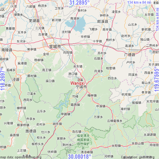
Wangxi GPS coordinates[2]
30° 41' 12.228" North, 118° 58' 22.152" East
| Map corner | latitude | longitude |
|---|---|---|
| Upper-left | 31.2895°, | 118.2697° |
| Center: | 30.68673°, | 118.97282° |
| Lower-right: | 30.08018°, | 119.67595° |
| Map W x H: | 134.5×134.5 km | = 83.6×83.6mi |
| max Lat: | 53.31946° ⇑48% North |
| Wangxi: | 30.68673° |
| min Lat: | ⇓52% South 18.22056° |
| min Long | Wangxi | max Long |
| 75.07348° | 118.97282° | 134.28917° |
| W 75.9%⇐ | ⇒24.1% E |
Elevation
Elevation of Wangxi is 45 m = 148 ft, and this is 439.8 m = 1443 ft below average elevation for this country.
| Max E: |
5622 m = 18445 ft | 71.9% |
| Avg. | 484.8 m = 1591 ft | |
| Wangxi | 45 m = 148 ft | |
Min E: |
-3 m = -10 ft | 28.1% |
See also: China elevation on elevation.city.
Geographical zone
Wangxi is located in North temperate zone (between Tropic of Cancer and the Arctic Circle). Distance of this Northern Tropic circle is 806.1 km =500.9 mi to South.| Distance of | km | miles | from Wangxi |
|---|---|---|---|
| North Pole | 6595 | 4097.9 | to North |
| Arctic Circle | 3989.1 | 2478.7 | to North |
| Tropic Cancer | 806.1 | 500.9 | to South |
| Equator | 3412 | 2120.1 | to South |


Nearby cities:
15 places around Wangxi: (largest is in red/bold)
• Gangkou
7.8 km =4.8 mi,  310°
310°
• Guxi
25.3 km =15.7 mi,  267°
267°
• Helixi
6.5 km =4 mi,  172°
172°
• Honglong
21.1 km =13.1 mi, 171°
• Meilin
16.8 km =10.4 mi,  142°
142°
• Qinglong
10.1 km =6.3 mi,  223°
223°
• Shuidong
11.4 km =7.1 mi,  351°
351°
• Sunbu
25.2 km =15.7 mi,  340°
340°
• Xiaxi
21.1 km =13.1 mi,  190°
190°
• Xintian
20.9 km =13 mi,  291°
291°
• Yalukou
4.9 km =3 mi,  124°
124°
• Yangtan
18.8 km =11.7 mi,  83°
83°
• Yishan
21.6 km =13.4 mi,  316°
316°
• Yuewan
17.8 km =11.1 mi,  64°
64°
• Zhufeng
13.6 km =8.5 mi, 194°
Sources, notices
• [Note1] Compared only with cities in China existing in our database
• [Src1] Map data: © OpenStreetMap contributors (CC-BY-SA)
• [Src2] Other city data from geonames.org with taken over terms of usage.
• [Src3] Geographical zone / Annual Mean Temperature by Robert A. Rohde @ Wikipedia
