Meilin geodata
Meilin (Anhui) is a seat of a fourth-order administrative division; located in China in Asia/Shanghai (GMT+8) time zone. In our database, there are 1268 cities with bigger population. Compared to other cities in China, 50.9% of cities are located further ↓South; 76.5% of cities are located further ←West and 65.8% of cities have higher elevation than Meilin. Note1


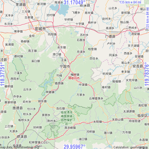
Meilin GPS coordinates[2]
30° 34' 1.092" North, 119° 4' 50.268" East
| Map corner | latitude | longitude |
|---|---|---|
| Upper-left | 31.17049°, | 118.37751° |
| Center: | 30.56697°, | 119.08063° |
| Lower-right: | 29.95967°, | 119.78376° |
| Map W x H: | 134.6×134.6 km | = 83.6×83.6mi |
| max Lat: | 53.31946° ⇑49.1% North |
| Meilin: | 30.56697° |
| min Lat: | ⇓50.9% South 18.22056° |
| min Long | Meilin | max Long |
| 75.07348° | 119.08063° | 134.28917° |
| W 76.5%⇐ | ⇒23.5% E |
Elevation
Elevation of Meilin is 69 m = 226 ft, and this is 415.8 m = 1364 ft below average elevation for this country.
| Max E: |
5622 m = 18445 ft | 65.8% |
| Avg. | 484.8 m = 1591 ft | |
| Meilin | 69 m = 226 ft | |
Min E: |
-3 m = -10 ft | 34.2% |
See also: China elevation on elevation.city.
Geographical zone
Meilin is located in North temperate zone (between Tropic of Cancer and the Arctic Circle). Distance of this Northern Tropic circle is 792.8 km =492.6 mi to South.| Distance of | km | miles | from Meilin |
|---|---|---|---|
| North Pole | 6608.3 | 4106.2 | to North |
| Arctic Circle | 4002.4 | 2487 | to North |
| Tropic Cancer | 792.8 | 492.6 | to South |
| Equator | 3398.7 | 2111.9 | to South |


Nearby cities:
15 places around Meilin: (largest is in red/bold)
• Gangkou
24.6 km =15.3 mi,  318°
318°
• Helixi
11.7 km =7.3 mi,  305°
305°
• Honglong
10.5 km =6.5 mi,  223°
223°
• Ningdun
12.3 km =7.6 mi,  167°
167°
• Qinglong
18.3 km =11.4 mi,  289°
289°
• Sihe
22.5 km =14 mi,  48°
48°
• Wangxi
16.8 km =10.4 mi, 322°
• Wanjia
18.8 km =11.7 mi,  164°
164°
• Xiaxi
16 km =9.9 mi,  242°
242°
• Yalukou
12.3 km =7.6 mi,  329°
329°
• Yangtan
17.6 km =10.9 mi,  28°
28°
• Yuewan
21.7 km =13.5 mi,  15°
15°
• Zhongxi
11.6 km =7.2 mi,  140°
140°
• Zhufeng
13.8 km =8.6 mi,  270°
270°
• Zhujiaqiao
18.7 km =11.6 mi,  183°
183°
Sources, notices
• [Note1] Compared only with cities in China existing in our database
• [Src1] Map data: © OpenStreetMap contributors (CC-BY-SA)
• [Src2] Other city data from geonames.org with taken over terms of usage.
• [Src3] Geographical zone / Annual Mean Temperature by Robert A. Rohde @ Wikipedia
