Gangkou geodata
Gangkou (Anhui) is a seat of a fourth-order administrative division; located in China in Asia/Shanghai (GMT+8) time zone. In our database, there are 1268 cities with bigger population. Compared to other cities in China, 52.4% of cities are located further ↓South; 75.6% of cities are located further ←West and 72.3% of cities have higher elevation than Gangkou. Note1


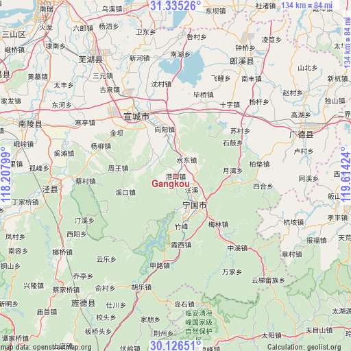
Gangkou GPS coordinates[2]
30° 43' 58.008" North, 118° 54' 39.996" East
| Map corner | latitude | longitude |
|---|---|---|
| Upper-left | 31.33526°, | 118.20799° |
| Center: | 30.73278°, | 118.91111° |
| Lower-right: | 30.12651°, | 119.61424° |
| Map W x H: | 134.4×134.4 km | = 83.5×83.5mi |
| max Lat: | 53.31946° ⇑47.6% North |
| Gangkou: | 30.73278° |
| min Lat: | ⇓52.4% South 18.22056° |
| min Long | Gangkou | max Long |
| 75.07348° | 118.91111° | 134.28917° |
| W 75.6%⇐ | ⇒24.4% E |
Elevation
Elevation of Gangkou is 44 m = 144 ft, and this is 440.8 m = 1446 ft below average elevation for this country.
| Max E: |
5622 m = 18445 ft | 72.3% |
| Avg. | 484.8 m = 1591 ft | |
| Gangkou | 44 m = 144 ft | |
Min E: |
-3 m = -10 ft | 27.7% |
See also: China elevation on elevation.city.
Geographical zone
Gangkou is located in North temperate zone (between Tropic of Cancer and the Arctic Circle). Distance of this Northern Tropic circle is 811.2 km =504.1 mi to South.| Distance of | km | miles | from Gangkou |
|---|---|---|---|
| North Pole | 6589.9 | 4094.8 | to North |
| Arctic Circle | 3984 | 2475.5 | to North |
| Tropic Cancer | 811.2 | 504.1 | to South |
| Equator | 3417.2 | 2123.3 | to South |


Nearby cities:
15 places around Gangkou: (largest is in red/bold)
• Guxi
20.3 km =12.6 mi,  252°
252°
• Helixi
13.4 km =8.3 mi,  149°
149°
• Meilin
24.6 km =15.3 mi,  138°
138°
• Qinglong
12.5 km =7.8 mi,  184°
184°
• Shuidong
7.4 km =4.6 mi,  33°
33°
• Sunbu
18.8 km =11.7 mi,  351°
351°
• Wangxi
7.8 km =4.8 mi,  130°
130°
• Xiangyang
18.6 km =11.6 mi, 346°
• Xintian
13.8 km =8.6 mi,  280°
280°
• Yalukou
12.7 km =7.9 mi, 128°
• Yangtan
24.7 km =15.3 mi,  96°
96°
• Yishan
13.9 km =8.6 mi,  319°
319°
• Yuewan
22.1 km =13.7 mi,  83°
83°
• Zhouwang
22.1 km =13.7 mi, 277°
• Zhufeng
18.5 km =11.5 mi,  172°
172°
Sources, notices
• [Note1] Compared only with cities in China existing in our database
• [Src1] Map data: © OpenStreetMap contributors (CC-BY-SA)
• [Src2] Other city data from geonames.org with taken over terms of usage.
• [Src3] Geographical zone / Annual Mean Temperature by Robert A. Rohde @ Wikipedia
