Tianxin geodata
Tianxin (Guangdong) is a seat of a fourth-order administrative division; located in China in Asia/Shanghai (GMT+8) time zone. In our database, there are 1268 cities with bigger population. Compared to other cities in China, 89.4% of cities are located further ↑North; 57% of cities are located further ←West and 51.4% of cities have lower elevation than Tianxin. Note1


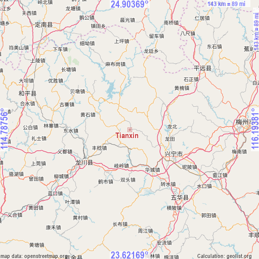
Tianxin GPS coordinates[2]
24° 15' 51.516" North, 115° 29' 26.448" East
| Map corner | latitude | longitude |
|---|---|---|
| Upper-left | 24.90369°, | 114.78756° |
| Center: | 24.26431°, | 115.49068° |
| Lower-right: | 23.62169°, | 116.19381° |
| Map W x H: | 142.5×142.5 km | = 88.5×88.5mi |
| max Lat: | 53.31946° ⇑89.4% North |
| Tianxin: | 24.26431° |
| min Lat: | ⇓10.6% South 18.22056° |
| min Long | Tianxin | max Long |
| 75.07348° | 115.49068° | 134.28917° |
| W 57%⇐ | ⇒43% E |
Elevation
Elevation of Tianxin is 176 m = 577 ft, and this is 308.8 m = 1013 ft below average elevation for this country.
| Max E: |
5622 m = 18445 ft | 48.6% |
| Avg. | 484.8 m = 1591 ft | |
| Tianxin | 176 m = 577 ft | |
Min E: |
-3 m = -10 ft | 51.4% |
See also: China elevation on elevation.city.
Geographical zone
Tianxin is located in North temperate zone (between Tropic of Cancer and the Arctic Circle). Distance of this Northern Tropic circle is 92 km =57.2 mi to South.| Distance of | km | miles | from Tianxin |
|---|---|---|---|
| North Pole | 7309.1 | 4541.7 | to North |
| Arctic Circle | 4703.2 | 2922.4 | to North |
| Tropic Cancer | 92 | 57.2 | to South |
| Equator | 2697.9 | 1676.4 | to South |


Nearby cities:
15 places around Tianxin: (largest is in red/bold)
• Chiguang
14.8 km =9.2 mi,  335°
335°
• Daping
11.3 km =7 mi,  51°
51°
• Fengren
19.4 km =12.1 mi,  238°
238°
• Guqian
11.3 km =7 mi,  216°
216°
• Heshui
21.1 km =13.1 mi,  94°
94°
• Huilong
12.3 km =7.6 mi,  16°
16°
• Lizui
18.5 km =11.5 mi,  298°
298°
• Longmu
5.6 km =3.5 mi,  269°
269°
• Pingyang
19.5 km =12.1 mi,  69°
69°
• Qiling
19.7 km =12.2 mi,  192°
192°
• Tiechang
11.1 km =6.9 mi,  179°
179°
• Xinqiao
14.7 km =9.1 mi,  147°
147°
• Xintian
21.6 km =13.4 mi,  7°
7°
• Yenan
17.4 km =10.8 mi,  119°
119°
• Yetang
19.1 km =11.9 mi,  114°
114°
Sources, notices
• [Note1] Compared only with cities in China existing in our database
• [Src1] Map data: © OpenStreetMap contributors (CC-BY-SA)
• [Src2] Other city data from geonames.org with taken over terms of usage.
• [Src3] Geographical zone / Annual Mean Temperature by Robert A. Rohde @ Wikipedia
