Tiandu geodata
Tiandu (Hainan) is a seat of a fourth-order administrative division; located in China in Asia/Shanghai (GMT+8) time zone. In our database, there are 1268 cities with bigger population. Compared to other cities in China, 100% of cities are located further ↑North; 73.5% of cities are located further →East and 84.3% of cities have higher elevation than Tiandu. Note1


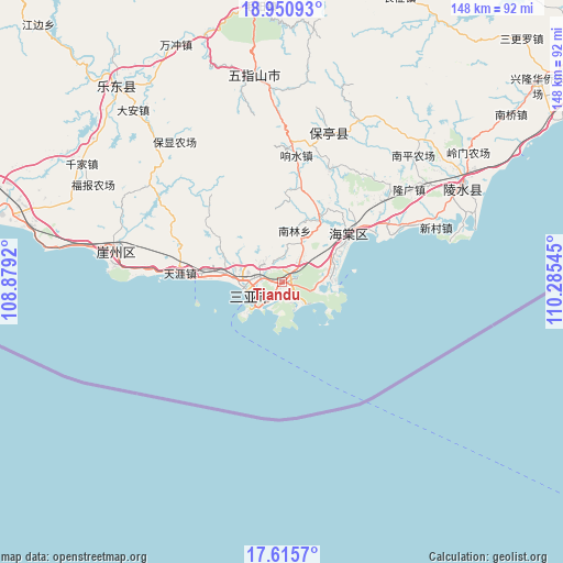
Tiandu GPS coordinates[2]
18° 17' 4.56" North, 109° 34' 56.352" East
| Map corner | latitude | longitude |
|---|---|---|
| Upper-left | 18.95093°, | 108.8792° |
| Center: | 18.2846°, | 109.58232° |
| Lower-right: | 17.6157°, | 110.28545° |
| Map W x H: | 148.5×148.5 km | = 92.3×92.3mi |
| max Lat: | 53.31946° ⇑100% North |
| Tiandu: | 18.2846° |
| min Lat: | ⇓0% South 18.22056° |
| min Long | Tiandu | max Long |
| 75.07348° | 109.58232° | 134.28917° |
| W 26.5%⇐ | ⇒73.5% E |
Elevation
Elevation of Tiandu is 17 m = 56 ft, and this is 467.8 m = 1535 ft below average elevation for this country.
| Max E: |
5622 m = 18445 ft | 84.3% |
| Avg. | 484.8 m = 1591 ft | |
| Tiandu | 17 m = 56 ft | |
Min E: |
-3 m = -10 ft | 15.7% |
See also: China elevation on elevation.city.
Geographical zone
Tiandu is located in North Torrid zone (between Equator and Tropic of Cancer). Distance of this Northern Tropic circle is 572.9 km =356 mi to North.| Distance of | km | miles | from Tiandu |
|---|---|---|---|
| North Pole | 7974 | 4954.8 | to North |
| Arctic Circle | 5368.1 | 3335.6 | to North |
| Tropic Cancer | 572.9 | 356 | to North |
| Equator | 2033.1 | 1263.3 | to South |


Nearby cities:
15 places around Tiandu: (largest is in red/bold)
• Baocheng
41.4 km =25.7 mi,  17°
17°
• Dadonghai
10.4 km =6.5 mi,  226°
226°
• Fenghuang
14.3 km =8.9 mi,  277°
277°
• Haitangwan
22.1 km =13.7 mi,  53°
53°
• Jiamao
32.6 km =20.3 mi, 21°
• Liugong
35.1 km =21.8 mi,  36°
36°
• Longguang
41.5 km =25.8 mi, 53°
• Nanlin
14.6 km =9.1 mi,  11°
11°
• Sandao
22.1 km =13.7 mi, 23°
• Sanya
9.4 km =5.8 mi,  240°
240°
• Tianya
27.1 km =16.8 mi, 275°
• Xiangshui
34.5 km =21.4 mi, 5°
• Xincun
42.8 km =26.6 mi,  70°
70°
• Xinzheng
29.1 km =18.1 mi, 8°
• Yingzhou
32 km =19.9 mi,  61°
61°
Sources, notices
• [Note1] Compared only with cities in China existing in our database
• [Src1] Map data: © OpenStreetMap contributors (CC-BY-SA)
• [Src2] Other city data from geonames.org with taken over terms of usage.
• [Src3] Geographical zone / Annual Mean Temperature by Robert A. Rohde @ Wikipedia
