Dadonghai geodata
Dadonghai (Hainan) is a populated place; located in China in Asia/Shanghai (GMT+8) time zone. With population of 2,000,000 people, there are 42 cities with bigger population in this country. Compared to other cities in China, 100% of cities are located further ↑North; 73.8% of cities are located further →East and 86.2% of cities have higher elevation than Dadonghai. Note1


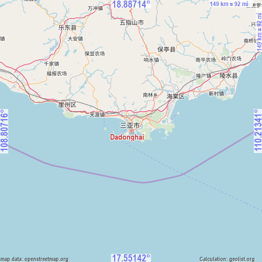
Dadonghai GPS coordinates[2]
18° 13' 14.016" North, 109° 30' 37.008" East
| Map corner | latitude | longitude |
|---|---|---|
| Upper-left | 18.88714°, | 108.80716° |
| Center: | 18.22056°, | 109.51028° |
| Lower-right: | 17.55142°, | 110.21341° |
| Map W x H: | 148.5×148.5 km | = 92.3×92.3mi |
| max Lat: | 53.31946° ⇑100% North |
| Dadonghai: | 18.22056° |
| min Lat: | ⇓0% South 18.22056° |
| min Long | Dadonghai | max Long |
| 75.07348° | 109.51028° | 134.28917° |
| W 26.2%⇐ | ⇒73.8% E |
Elevation
Elevation of Dadonghai is 14 m = 46 ft, and this is 470.8 m = 1545 ft below average elevation for this country.
| Max E: |
5622 m = 18445 ft | 86.2% |
| Avg. | 484.8 m = 1591 ft | |
| Dadonghai | 14 m = 46 ft | |
Min E: |
-3 m = -10 ft | 13.8% |
See also: Dadonghai elevation on elevation.city.
Geographical zone
Dadonghai is located in North Torrid zone (between Equator and Tropic of Cancer). Distance of this Northern Tropic circle is 580 km =360.4 mi to North.| Distance of | km | miles | from Dadonghai |
|---|---|---|---|
| North Pole | 7981.1 | 4959.2 | to North |
| Arctic Circle | 5375.2 | 3340 | to North |
| Tropic Cancer | 580 | 360.4 | to North |
| Equator | 2025.9 | 1258.8 | to South |


Nearby cities:
15 places around Dadonghai: (largest is in red/bold)
• Baocheng
50.8 km =31.6 mi,  23°
23°
• Fenghuang
11.1 km =6.9 mi,  323°
323°
• Haitangwan
32.5 km =20.2 mi,  51°
51°
• Jiamao
42.2 km =26.2 mi,  27°
27°
• Liugong
45.4 km =28.2 mi,  38°
38°
• Nanlin
23.8 km =14.8 mi, 26°
• Sandao
31.9 km =19.8 mi, 30°
• Sanya
2.6 km =1.6 mi,  347°
347°
• Tiandu
10.4 km =6.5 mi, 46°
• Tianya
21.7 km =13.5 mi,  296°
296°
• Xiangshui
42.8 km =26.6 mi,  14°
14°
• Xinzheng
37.8 km =23.5 mi, 18°
• Yacheng
40.4 km =25.1 mi, 295°
• Yingzhou
42.2 km =26.2 mi,  58°
58°
• Zhizhong
51.3 km =31.9 mi,  329°
329°
Sources, notices
• [Note1] Compared only with cities in China existing in our database
• [Src1] Map data: © OpenStreetMap contributors (CC-BY-SA)
• [Src2] Other city data from geonames.org with taken over terms of usage.
• [Src3] Geographical zone / Annual Mean Temperature by Robert A. Rohde @ Wikipedia
