Tengzhou geodata
Tengzhou (Guangxi) is a seat of a third-order administrative division; located in China in Asia/Shanghai (GMT+8) time zone. In our database, there are 1268 cities with bigger population. Compared to other cities in China, 92.7% of cities are located further ↑North; 67.5% of cities are located further →East and 73.7% of cities have higher elevation than Tengzhou. Note1


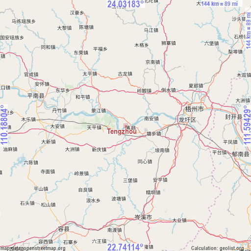
Tengzhou GPS coordinates[2]
23° 23' 17.016" North, 110° 53' 28.176" East
| Map corner | latitude | longitude |
|---|---|---|
| Upper-left | 24.03183°, | 110.18804° |
| Center: | 23.38806°, | 110.89116° |
| Lower-right: | 22.74114°, | 111.59429° |
| Map W x H: | 143.5×143.5 km | = 89.2×89.2mi |
| max Lat: | 53.31946° ⇑92.7% North |
| Tengzhou: | 23.38806° |
| min Lat: | ⇓7.3% South 18.22056° |
| min Long | Tengzhou | max Long |
| 75.07348° | 110.89116° | 134.28917° |
| W 32.5%⇐ | ⇒67.5% E |
Elevation
Elevation of Tengzhou is 40 m = 131 ft, and this is 444.8 m = 1459 ft below average elevation for this country.
| Max E: |
5622 m = 18445 ft | 73.7% |
| Avg. | 484.8 m = 1591 ft | |
| Tengzhou | 40 m = 131 ft | |
Min E: |
-3 m = -10 ft | 26.3% |
See also: China elevation on elevation.city.
Geographical zone
Tengzhou is located in North Torrid zone (between Equator and Tropic of Cancer). Distance of this Northern Tropic circle is 5.4 km =3.4 mi to North.| Distance of | km | miles | from Tengzhou |
|---|---|---|---|
| North Pole | 7406.6 | 4602.2 | to North |
| Arctic Circle | 4800.7 | 2983 | to North |
| Tropic Cancer | 5.4 | 3.4 | to North |
| Equator | 2600.5 | 1615.9 | to South |


Nearby cities:
15 places around Tengzhou: (largest is in red/bold)
• Changgang
71.3 km =44.3 mi,  99°
99°
• Dazhou
67.6 km =42 mi,  77°
77°
• Ducheng
67.1 km =41.7 mi, 104°
• Guixu
63.7 km =39.6 mi,  114°
114°
• Jiancheng
71.8 km =44.6 mi, 112°
• Jiangchuan
59.3 km =36.8 mi,  88°
88°
• Jiangkou
62.1 km =38.6 mi, 84°
• Jinji
19 km =11.8 mi,  200°
200°
• Longxu
35.1 km =21.8 mi, 84°
• Nandu
60 km =37.3 mi,  186°
186°
• Pingfeng
59.8 km =37.2 mi, 99°
• Pingnan
54 km =33.6 mi,  288°
288°
• Pingtai
55.7 km =34.6 mi, 105°
• Rongcheng
68.6 km =42.6 mi,  210°
210°
• Wuzhou
44.7 km =27.8 mi, 76°
Sources, notices
• [Note1] Compared only with cities in China existing in our database
• [Src1] Map data: © OpenStreetMap contributors (CC-BY-SA)
• [Src2] Other city data from geonames.org with taken over terms of usage.
• [Src3] Geographical zone / Annual Mean Temperature by Robert A. Rohde @ Wikipedia
