Kunshan geodata
Kunshan (Jiangsu) is a seat of a third-order administrative division; located in China in Asia/Shanghai (GMT+8) time zone. With population of 1,600,000 people, there are 46 cities with bigger population in this country. Compared to other cities in China, 57.6% of cities are located further ↓South; 87.6% of cities are located further ←West and 89.9% of cities have higher elevation than Kunshan. Note1


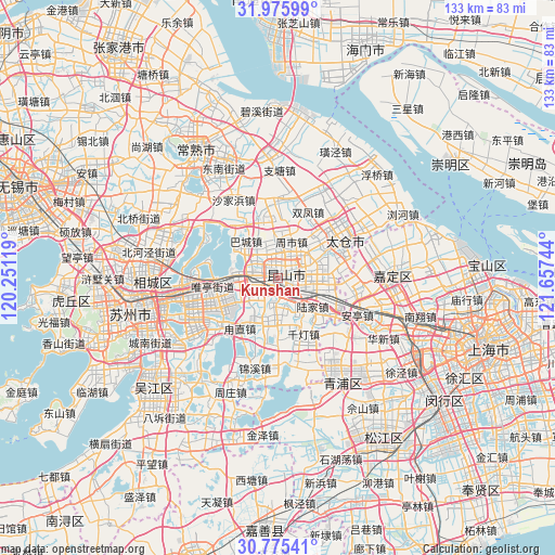
Kunshan GPS coordinates[2]
31° 22' 39.432" North, 120° 57' 15.516" East
| Map corner | latitude | longitude |
|---|---|---|
| Upper-left | 31.97599°, | 120.25119° |
| Center: | 31.37762°, | 120.95431° |
| Lower-right: | 30.77541°, | 121.65744° |
| Map W x H: | 133.5×133.5 km | = 83×83mi |
| max Lat: | 53.31946° ⇑42.4% North |
| Kunshan: | 31.37762° |
| min Lat: | ⇓57.6% South 18.22056° |
| min Long | Kunshan | max Long |
| 75.07348° | 120.95431° | 134.28917° |
| W 87.6%⇐ | ⇒12.4% E |
Elevation
Elevation of Kunshan is 10 m = 33 ft, and this is 474.8 m = 1558 ft below average elevation for this country.
| Max E: |
5622 m = 18445 ft | 89.9% |
| Avg. | 484.8 m = 1591 ft | |
| Kunshan | 10 m = 33 ft | |
Min E: |
-3 m = -10 ft | 10.1% |
See also: Kunshan elevation on elevation.city.
Geographical zone
Kunshan is located in North temperate zone (between Tropic of Cancer and the Arctic Circle). Distance of this Northern Tropic circle is 882.9 km =548.6 mi to South.| Distance of | km | miles | from Kunshan |
|---|---|---|---|
| North Pole | 6518.2 | 4050.2 | to North |
| Arctic Circle | 3912.3 | 2431 | to North |
| Tropic Cancer | 882.9 | 548.6 | to South |
| Equator | 3488.9 | 2167.9 | to South |


Nearby cities:
15 places around Kunshan: (largest is in red/bold)
• Anting
21.2 km =13.2 mi,  114°
114°
• Bacheng
11.8 km =7.3 mi,  319°
319°
• Baihe
22 km =13.7 mi,  127°
127°
• Chengxiang
15.4 km =9.6 mi,  59°
59°
• Dianshanhu
22.5 km =14 mi,  162°
162°
• Huaqiao
15 km =9.3 mi,  124°
124°
• Lujia
10.9 km =6.8 mi, 129°
• Luzhi
13.9 km =8.6 mi,  216°
216°
• Qiandeng
13 km =8.1 mi, 161°
• Shajiabang
21.5 km =13.4 mi,  332°
332°
• Shengpu
15.3 km =9.5 mi,  238°
238°
• Shuangfeng
16.9 km =10.5 mi,  23°
23°
• Waigang
20.6 km =12.8 mi,  94°
94°
• Zhangpu
10.1 km =6.3 mi,  183°
183°
• Zhoushi
10.3 km =6.4 mi, 19°
Sources, notices
• [Note1] Compared only with cities in China existing in our database
• [Src1] Map data: © OpenStreetMap contributors (CC-BY-SA)
• [Src2] Other city data from geonames.org with taken over terms of usage.
• [Src3] Geographical zone / Annual Mean Temperature by Robert A. Rohde @ Wikipedia
