Lujia geodata
Lujia (Jiangsu) is a seat of a fourth-order administrative division; located in China in Asia/Shanghai (GMT+8) time zone. In our database, there are 1268 cities with bigger population. Compared to other cities in China, 57.2% of cities are located further ↓South; 88% of cities are located further ←West and 92.7% of cities have higher elevation than Lujia. Note1


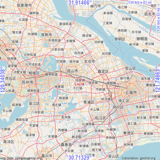
Lujia GPS coordinates[2]
31° 18' 57.204" North, 121° 2' 36.6" East
| Map corner | latitude | longitude |
|---|---|---|
| Upper-left | 31.91466°, | 120.34038° |
| Center: | 31.31589°, | 121.0435° |
| Lower-right: | 30.71329°, | 121.74663° |
| Map W x H: | 133.6×133.6 km | = 83×83mi |
| max Lat: | 53.31946° ⇑42.8% North |
| Lujia: | 31.31589° |
| min Lat: | ⇓57.2% South 18.22056° |
| min Long | Lujia | max Long |
| 75.07348° | 121.0435° | 134.28917° |
| W 88%⇐ | ⇒12% E |
Elevation
Elevation of Lujia is 8 m = 26 ft, and this is 476.8 m = 1564 ft below average elevation for this country.
| Max E: |
5622 m = 18445 ft | 92.7% |
| Avg. | 484.8 m = 1591 ft | |
| Lujia | 8 m = 26 ft | |
Min E: |
-3 m = -10 ft | 7.3% |
See also: China elevation on elevation.city.
Geographical zone
Lujia is located in North temperate zone (between Tropic of Cancer and the Arctic Circle). Distance of this Northern Tropic circle is 876.1 km =544.4 mi to South.| Distance of | km | miles | from Lujia |
|---|---|---|---|
| North Pole | 6525.1 | 4054.5 | to North |
| Arctic Circle | 3919.2 | 2435.3 | to North |
| Tropic Cancer | 876.1 | 544.4 | to South |
| Equator | 3482 | 2163.6 | to South |


Nearby cities:
15 places around Lujia: (largest is in red/bold)
• Anting
11 km =6.8 mi,  99°
99°
• Baihe
11.1 km =6.9 mi,  126°
126°
• Chengxiang
15.4 km =9.6 mi,  18°
18°
• Chonggu
17.4 km =10.8 mi,  135°
135°
• Dianshanhu
14.8 km =9.2 mi,  186°
186°
• Huangdu
16.2 km =10.1 mi,  105°
105°
• Huaqiao
4.2 km =2.6 mi, 112°
• Huaxin
18.3 km =11.4 mi, 114°
• Kunshan
10.9 km =6.8 mi,  309°
309°
• Luzhi
17.3 km =10.7 mi,  255°
255°
• Qiandeng
7 km =4.3 mi,  219°
219°
• Waigang
13.2 km =8.2 mi,  66°
66°
• Xianghuaqiao
17.2 km =10.7 mi,  156°
156°
• Zhangpu
9.6 km =6 mi,  250°
250°
• Zhoushi
17.3 km =10.7 mi,  342°
342°
Sources, notices
• [Note1] Compared only with cities in China existing in our database
• [Src1] Map data: © OpenStreetMap contributors (CC-BY-SA)
• [Src2] Other city data from geonames.org with taken over terms of usage.
• [Src3] Geographical zone / Annual Mean Temperature by Robert A. Rohde @ Wikipedia
