Tangjiapo geodata
Tangjiapo (Shandong) is a seat of a fourth-order administrative division; located in China in Asia/Shanghai (GMT+8) time zone. In our database, there are 1268 cities with bigger population. Compared to other cities in China, 79.7% of cities are located further ↓South; 87.7% of cities are located further ←West and 52.9% of cities have lower elevation than Tangjiapo. Note1


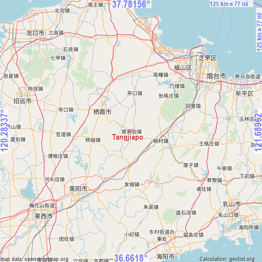
Tangjiapo GPS coordinates[2]
37° 13' 25.536" North, 120° 59' 11.364" East
| Map corner | latitude | longitude |
|---|---|---|
| Upper-left | 37.78156°, | 120.28337° |
| Center: | 37.22376°, | 120.98649° |
| Lower-right: | 36.6618°, | 121.68962° |
| Map W x H: | 124.5×124.5 km | = 77.4×77.4mi |
| max Lat: | 53.31946° ⇑20.3% North |
| Tangjiapo: | 37.22376° |
| min Lat: | ⇓79.7% South 18.22056° |
| min Long | Tangjiapo | max Long |
| 75.07348° | 120.98649° | 134.28917° |
| W 87.7%⇐ | ⇒12.3% E |
Elevation
Elevation of Tangjiapo is 188 m = 617 ft, and this is 296.8 m = 974 ft below average elevation for this country.
| Max E: |
5622 m = 18445 ft | 47.1% |
| Avg. | 484.8 m = 1591 ft | |
| Tangjiapo | 188 m = 617 ft | |
Min E: |
-3 m = -10 ft | 52.9% |
See also: China elevation on elevation.city.
Geographical zone
Tangjiapo is located in North temperate zone (between Tropic of Cancer and the Arctic Circle). Distance of this Northern Tropic circle is 1533 km =952.6 mi to South.| Distance of | km | miles | from Tangjiapo |
|---|---|---|---|
| North Pole | 5868.2 | 3646.3 | to North |
| Arctic Circle | 3262.3 | 2027.1 | to North |
| Tropic Cancer | 1533 | 952.6 | to South |
| Equator | 4138.9 | 2571.8 | to South |


Nearby cities:
15 places around Tangjiapo: (largest is in red/bold)
• Gaotuan
30.3 km =18.8 mi,  27°
27°
• Guanli
26.4 km =16.4 mi,  260°
260°
• Guanshui
24.5 km =15.2 mi,  91°
91°
• Huili
31.8 km =19.8 mi,  67°
67°
• Menlou
30.6 km =19 mi,  45°
45°
• Muyudian
29.9 km =18.6 mi,  223°
223°
• Shanqiandian
25.6 km =15.9 mi,  204°
204°
• Shewopo
14.8 km =9.2 mi,  227°
227°
• Songshan
23.5 km =14.6 mi,  331°
331°
• Xicheng
23 km =14.3 mi,  296°
296°
• Xujiadian
15.9 km =9.9 mi,  180°
180°
• Yangchu
18.6 km =11.6 mi, 258°
• Zangjiazhuang
26.9 km =16.7 mi,  359°
359°
• Zhanggezhuang
24.4 km =15.2 mi, 46°
• Zhuangyuan
16.8 km =10.4 mi, 302°
Sources, notices
• [Note1] Compared only with cities in China existing in our database
• [Src1] Map data: © OpenStreetMap contributors (CC-BY-SA)
• [Src2] Other city data from geonames.org with taken over terms of usage.
• [Src3] Geographical zone / Annual Mean Temperature by Robert A. Rohde @ Wikipedia
