Siquanpu geodata
Siquanpu (Jiangxi) is a seat of a fourth-order administrative division; located in China in Asia/Shanghai (GMT+8) time zone. In our database, there are 1268 cities with bigger population. Compared to other cities in China, 72.7% of cities are located further ↑North; 52.1% of cities are located further ←West and 61.1% of cities have higher elevation than Siquanpu. Note1


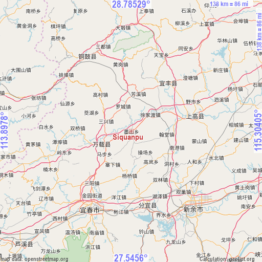
Siquanpu GPS coordinates[2]
28° 10' 2.064" North, 114° 36' 3.312" East
| Map corner | latitude | longitude |
|---|---|---|
| Upper-left | 28.78529°, | 113.8978° |
| Center: | 28.16724°, | 114.60092° |
| Lower-right: | 27.5456°, | 115.30405° |
| Map W x H: | 137.8×137.8 km | = 85.6×85.6mi |
| max Lat: | 53.31946° ⇑72.7% North |
| Siquanpu: | 28.16724° |
| min Lat: | ⇓27.3% South 18.22056° |
| min Long | Siquanpu | max Long |
| 75.07348° | 114.60092° | 134.28917° |
| W 52.1%⇐ | ⇒47.9% E |
Elevation
Elevation of Siquanpu is 92 m = 302 ft, and this is 392.8 m = 1289 ft below average elevation for this country.
| Max E: |
5622 m = 18445 ft | 61.1% |
| Avg. | 484.8 m = 1591 ft | |
| Siquanpu | 92 m = 302 ft | |
Min E: |
-3 m = -10 ft | 38.9% |
See also: China elevation on elevation.city.
Geographical zone
Siquanpu is located in North temperate zone (between Tropic of Cancer and the Arctic Circle). Distance of this Northern Tropic circle is 526 km =326.8 mi to South.| Distance of | km | miles | from Siquanpu |
|---|---|---|---|
| North Pole | 6875.2 | 4272 | to North |
| Arctic Circle | 4269.3 | 2652.8 | to North |
| Tropic Cancer | 526 | 326.8 | to South |
| Equator | 3131.9 | 1946.1 | to South |


Nearby cities:
15 places around Siquanpu: (largest is in red/bold)
• Bailiang
18.9 km =11.7 mi,  281°
281°
• Caochang
12.8 km =8 mi,  146°
146°
• Efeng
15.8 km =9.8 mi,  247°
247°
• Fangxi
20.1 km =12.5 mi,  10°
10°
• Gaolan
18.9 km =11.7 mi, 146°
• Hantang
18.5 km =11.5 mi,  94°
94°
• Kangle
16.8 km =10.4 mi,  241°
241°
• Luocheng
14.1 km =8.8 mi,  340°
340°
• Mabu
17.7 km =11 mi, 245°
• Sanxing
14.7 km =9.1 mi,  291°
291°
• Shishi
19.6 km =12.2 mi,  58°
58°
• Tianxin
3.5 km =2.2 mi,  175°
175°
• Xujiadu
13.3 km =8.3 mi,  48°
48°
• Zhaixia
20.2 km =12.6 mi,  210°
210°
• Zhendu
4 km =2.5 mi,  358°
358°
Sources, notices
• [Note1] Compared only with cities in China existing in our database
• [Src1] Map data: © OpenStreetMap contributors (CC-BY-SA)
• [Src2] Other city data from geonames.org with taken over terms of usage.
• [Src3] Geographical zone / Annual Mean Temperature by Robert A. Rohde @ Wikipedia
