Zhaixia geodata
Zhaixia (Jiangxi) is a seat of a fourth-order administrative division; located in China in Asia/Shanghai (GMT+8) time zone. In our database, there are 1268 cities with bigger population. Compared to other cities in China, 74% of cities are located further ↑North; 51.6% of cities are located further ←West and 51.9% of cities have lower elevation than Zhaixia. Note1


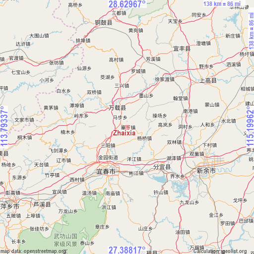
Zhaixia GPS coordinates[2]
28° 0' 38.556" North, 114° 29' 47.364" East
| Map corner | latitude | longitude |
|---|---|---|
| Upper-left | 28.62967°, | 113.79337° |
| Center: | 28.01071°, | 114.49649° |
| Lower-right: | 27.38817°, | 115.19962° |
| Map W x H: | 138×138 km | = 85.7×85.7mi |
| max Lat: | 53.31946° ⇑74% North |
| Zhaixia: | 28.01071° |
| min Lat: | ⇓26% South 18.22056° |
| min Long | Zhaixia | max Long |
| 75.07348° | 114.49649° | 134.28917° |
| W 51.6%⇐ | ⇒48.4% E |
Elevation
Elevation of Zhaixia is 180 m = 591 ft, and this is 304.8 m = 1000 ft below average elevation for this country.
| Max E: |
5622 m = 18445 ft | 48.1% |
| Avg. | 484.8 m = 1591 ft | |
| Zhaixia | 180 m = 591 ft | |
Min E: |
-3 m = -10 ft | 51.9% |
See also: China elevation on elevation.city.
Geographical zone
Zhaixia is located in North temperate zone (between Tropic of Cancer and the Arctic Circle). Distance of this Northern Tropic circle is 508.6 km =316 mi to South.| Distance of | km | miles | from Zhaixia |
|---|---|---|---|
| North Pole | 6892.6 | 4282.9 | to North |
| Arctic Circle | 4286.7 | 2663.6 | to North |
| Tropic Cancer | 508.6 | 316 | to South |
| Equator | 3114.5 | 1935.3 | to South |


Nearby cities:
15 places around Zhaixia: (largest is in red/bold)
• Baimu
6.4 km =4 mi,  260°
260°
• Caochang
18.5 km =11.5 mi,  68°
68°
• Efeng
12 km =7.5 mi,  338°
338°
• Fengdingshan
20.9 km =13 mi,  270°
270°
• Gaocheng
17.6 km =10.9 mi,  305°
305°
• Gaolan
20.6 km =12.8 mi,  85°
85°
• Kangle
10.5 km =6.5 mi,  334°
334°
• Lucun
10.1 km =6.3 mi,  203°
203°
• Mabu
11.5 km =7.1 mi, 329°
• Sanyang
14.4 km =8.9 mi,  227°
227°
• Siquanpu
20.2 km =12.6 mi,  30°
30°
• Tianxin
17.4 km =10.8 mi,  37°
37°
• Wojiang
19.8 km =12.3 mi, 197°
• Yangjiang
17.5 km =10.9 mi,  167°
167°
• Yangqiao
10.9 km =6.8 mi,  122°
122°
Sources, notices
• [Note1] Compared only with cities in China existing in our database
• [Src1] Map data: © OpenStreetMap contributors (CC-BY-SA)
• [Src2] Other city data from geonames.org with taken over terms of usage.
• [Src3] Geographical zone / Annual Mean Temperature by Robert A. Rohde @ Wikipedia
