Laixi geodata
Laixi (Shandong) is a populated place; located in China in Asia/Shanghai (GMT+8) time zone. With population of 75,849 people, there are 565 cities with bigger population in this country. Compared to other cities in China, 78.9% of cities are located further ↓South; 85.2% of cities are located further ←West and 69.5% of cities have higher elevation than Laixi. Note1


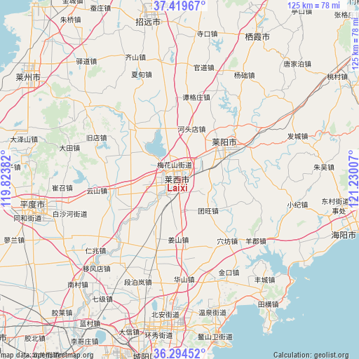
Laixi GPS coordinates[2]
36° 51' 33.012" North, 120° 31' 36.984" East
| Map corner | latitude | longitude |
|---|---|---|
| Upper-left | 37.41967°, | 119.82382° |
| Center: | 36.85917°, | 120.52694° |
| Lower-right: | 36.29452°, | 121.23007° |
| Map W x H: | 125.1×125.1 km | = 77.7×77.7mi |
| max Lat: | 53.31946° ⇑21.1% North |
| Laixi: | 36.85917° |
| min Lat: | ⇓78.9% South 18.22056° |
| min Long | Laixi | max Long |
| 75.07348° | 120.52694° | 134.28917° |
| W 85.2%⇐ | ⇒14.8% E |
Elevation
Elevation of Laixi is 54 m = 177 ft, and this is 430.8 m = 1413 ft below average elevation for this country.
| Max E: |
5622 m = 18445 ft | 69.5% |
| Avg. | 484.8 m = 1591 ft | |
| Laixi | 54 m = 177 ft | |
Min E: |
-3 m = -10 ft | 30.5% |
See also: Laixi elevation on elevation.city.
Geographical zone
Laixi is located in North temperate zone (between Tropic of Cancer and the Arctic Circle). Distance of this Northern Tropic circle is 1492.4 km =927.3 mi to South.| Distance of | km | miles | from Laixi |
|---|---|---|---|
| North Pole | 5908.7 | 3671.5 | to North |
| Arctic Circle | 3302.8 | 2052.3 | to North |
| Tropic Cancer | 1492.4 | 927.3 | to South |
| Equator | 4098.4 | 2546.6 | to South |


Nearby cities:
15 places around Laixi: (largest is in red/bold)
• Biguo
40.1 km =24.9 mi,  3°
3°
• Guandao
40 km =24.9 mi,  12°
12°
• Guanli
39.1 km =24.3 mi,  22°
22°
• Guojiadian
41.2 km =25.6 mi,  307°
307°
• Hetoudian
18.2 km =11.3 mi, 13°
• Laiyang
21.1 km =13.1 mi,  51°
51°
• Malianzhuang
24.7 km =15.3 mi,  346°
346°
• Muyudian
27.7 km =17.2 mi, 46°
• Nanshu
24.6 km =15.3 mi,  316°
316°
• Qicai
45.5 km =28.3 mi,  340°
340°
• Shanqiandian
34.9 km =21.7 mi,  60°
60°
• Shewopo
42.7 km =26.5 mi,  44°
44°
• Tangezhuang
29.5 km =18.3 mi, 11°
• Xiadian
39 km =24.2 mi, 340°
• Yangchu
43.2 km =26.8 mi,  31°
31°
Sources, notices
• [Note1] Compared only with cities in China existing in our database
• [Src1] Map data: © OpenStreetMap contributors (CC-BY-SA)
• [Src2] Other city data from geonames.org with taken over terms of usage.
• [Src3] Geographical zone / Annual Mean Temperature by Robert A. Rohde @ Wikipedia
