Shuanglu geodata
Shuanglu (Chongqing) is a seat of a fourth-order administrative division; located in China in Asia/Shanghai (GMT+8) time zone. In our database, there are 1268 cities with bigger population. Compared to other cities in China, 55.5% of cities are located further ↑North; 81.3% of cities are located further →East and 72.8% of cities have lower elevation than Shuanglu. Note1


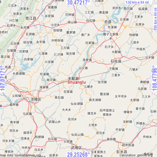
Shuanglu GPS coordinates[2]
29° 51' 51.444" North, 107° 46' 29.388" East
| Map corner | latitude | longitude |
|---|---|---|
| Upper-left | 30.47217°, | 107.07171° |
| Center: | 29.86429°, | 107.77483° |
| Lower-right: | 29.25268°, | 108.47796° |
| Map W x H: | 135.6×135.6 km | = 84.3×84.3mi |
| max Lat: | 53.31946° ⇑55.5% North |
| Shuanglu: | 29.86429° |
| min Lat: | ⇓44.5% South 18.22056° |
| min Long | Shuanglu | max Long |
| 75.07348° | 107.77483° | 134.28917° |
| W 18.7%⇐ | ⇒81.3% E |
Elevation
Elevation of Shuanglu is 471 m = 1545 ft, and this is 13.8 m = 45 ft below average elevation for this country.
| Max E: |
5622 m = 18445 ft | 27.2% |
| Avg. | 484.8 m = 1591 ft | |
| Shuanglu | 471 m = 1545 ft | |
Min E: |
-3 m = -10 ft | 72.8% |
See also: China elevation on elevation.city.
Geographical zone
Shuanglu is located in North temperate zone (between Tropic of Cancer and the Arctic Circle). Distance of this Northern Tropic circle is 714.7 km =444.1 mi to South.| Distance of | km | miles | from Shuanglu |
|---|---|---|---|
| North Pole | 6686.5 | 4154.8 | to North |
| Arctic Circle | 4080.6 | 2535.6 | to North |
| Tropic Cancer | 714.7 | 444.1 | to South |
| Equator | 3320.6 | 2063.3 | to South |


Nearby cities:
15 places around Shuanglu: (largest is in red/bold)
• Baoluan
14.5 km =9 mi,  219°
219°
• Gaojia
19.2 km =11.9 mi,  25°
25°
• Huwei
13.9 km =8.6 mi,  289°
289°
• Lizi
15.6 km =9.7 mi,  112°
112°
• Longhe
20.5 km =12.7 mi,  97°
97°
• Luoyun
19.4 km =12.1 mi,  241°
241°
• Renyi
17.8 km =11.1 mi,  277°
277°
• Sanba
21.4 km =13.3 mi,  184°
184°
• Sanhe
4.3 km =2.7 mi, 276°
• Sanjian
10.8 km =6.7 mi,  127°
127°
• Shetan
20.7 km =12.9 mi,  312°
312°
• Shizhi
21.1 km =13.1 mi,  5°
5°
• Shuren
14 km =8.7 mi,  345°
345°
• Xingyi
10.9 km =6.8 mi,  21°
21°
• Zhanpu
13.5 km =8.4 mi,  260°
260°
Sources, notices
• [Note1] Compared only with cities in China existing in our database
• [Src1] Map data: © OpenStreetMap contributors (CC-BY-SA)
• [Src2] Other city data from geonames.org with taken over terms of usage.
• [Src3] Geographical zone / Annual Mean Temperature by Robert A. Rohde @ Wikipedia
