Baoluan geodata
Baoluan (Chongqing) is a seat of a fourth-order administrative division; located in China in Asia/Shanghai (GMT+8) time zone. In our database, there are 1268 cities with bigger population. Compared to other cities in China, 56.7% of cities are located further ↑North; 81.6% of cities are located further →East and 75.9% of cities have lower elevation than Baoluan. Note1


Baoluan GPS coordinates[2]
29° 45' 50.976" North, 107° 40' 42.024" East
| Map corner | latitude | longitude |
|---|---|---|
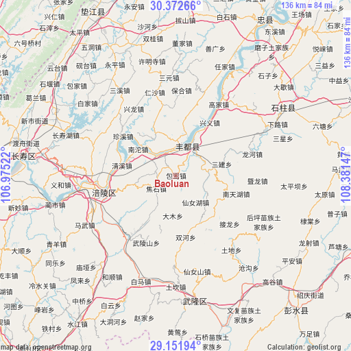
| Upper-left | 30.37266°, | 106.97522° |
| Center: | 29.76416°, | 107.67834° |
| Lower-right: | 29.15194°, | 108.38147° |
| Map W x H: | 135.7×135.7 km | = 84.3×84.3mi |
| max Lat: | 53.31946° ⇑56.7% North |
| Baoluan: | 29.76416° |
| min Lat: | ⇓43.3% South 18.22056° |
| min Long | Baoluan | max Long |
| 75.07348° | 107.67834° | 134.28917° |
| W 18.4%⇐ | ⇒81.6% E |
Elevation
Elevation of Baoluan is 543 m = 1781 ft, and this is 58.2 m = 191 ft above average elevation for this country.
| Max E: |
5622 m = 18445 ft | 24.1% |
| Baoluan | 543 m 1781 ft | |
| Avg. | 484.8 m = 1591 ft | |
Min E: |
-3 m = -10 ft | 75.9% |
See also: China elevation on elevation.city.
Geographical zone
Baoluan is located in North temperate zone (between Tropic of Cancer and the Arctic Circle). Distance of this Northern Tropic circle is 703.5 km =437.1 mi to South.| Distance of | km | miles | from Baoluan |
|---|---|---|---|
| North Pole | 6697.6 | 4161.7 | to North |
| Arctic Circle | 4091.7 | 2542.5 | to North |
| Tropic Cancer | 703.5 | 437.1 | to South |
| Equator | 3309.5 | 2056.4 | to South |


Nearby cities:
15 places around Baoluan: (largest is in red/bold)
• Damu
16.2 km =10.1 mi,  185°
185°
• Huwei
16.2 km =10.1 mi,  346°
346°
• Jiaoshi
9.5 km =5.9 mi,  235°
235°
• Lizi
24.3 km =15.1 mi,  77°
77°
• Luoyun
8 km =5 mi,  283°
283°
• Nantuo
18.8 km =11.7 mi,  304°
304°
• Qingxi
21.6 km =13.4 mi, 280°
• Renyi
15.9 km =9.9 mi,  328°
328°
• Sanba
12.8 km =8 mi,  142°
142°
• Sanhe
12.7 km =7.9 mi,  23°
23°
• Sanjian
18.5 km =11.5 mi, 75°
• Shanwo
20.2 km =12.6 mi,  212°
212°
• Shuanghe
24.2 km =15 mi,  170°
170°
• Shuanglu
14.5 km =9 mi,  39°
39°
• Zhanpu
9.8 km =6.1 mi,  335°
335°
Sources, notices
• [Note1] Compared only with cities in China existing in our database
• [Src1] Map data: © OpenStreetMap contributors (CC-BY-SA)
• [Src2] Other city data from geonames.org with taken over terms of usage.
• [Src3] Geographical zone / Annual Mean Temperature by Robert A. Rohde @ Wikipedia
