Shizhuang geodata
Shizhuang (Jiangsu) is a seat of a fourth-order administrative division; located in China in Asia/Shanghai (GMT+8) time zone. In our database, there are 1268 cities with bigger population. Compared to other cities in China, 60.7% of cities are located further ↓South; 82.1% of cities are located further ←West and 95.9% of cities have higher elevation than Shizhuang. Note1


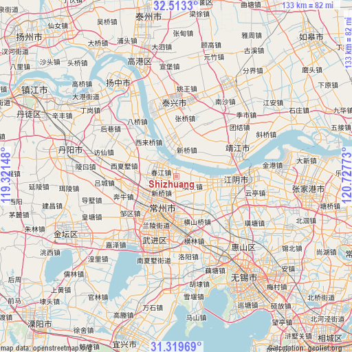
Shizhuang GPS coordinates[2]
31° 55' 6.348" North, 120° 1' 28.56" East
| Map corner | latitude | longitude |
|---|---|---|
| Upper-left | 32.5133°, | 119.32148° |
| Center: | 31.91843°, | 120.0246° |
| Lower-right: | 31.31969°, | 120.72773° |
| Map W x H: | 132.7×132.7 km | = 82.5×82.5mi |
| max Lat: | 53.31946° ⇑39.3% North |
| Shizhuang: | 31.91843° |
| min Lat: | ⇓60.7% South 18.22056° |
| min Long | Shizhuang | max Long |
| 75.07348° | 120.0246° | 134.28917° |
| W 82.1%⇐ | ⇒17.9% E |
Elevation
Elevation of Shizhuang is 6 m = 20 ft, and this is 478.8 m = 1571 ft below average elevation for this country.
| Max E: |
5622 m = 18445 ft | 95.9% |
| Avg. | 484.8 m = 1591 ft | |
| Shizhuang | 6 m = 20 ft | |
Min E: |
-3 m = -10 ft | 4.1% |
See also: China elevation on elevation.city.
Geographical zone
Shizhuang is located in North temperate zone (between Tropic of Cancer and the Arctic Circle). Distance of this Northern Tropic circle is 943.1 km =586 mi to South.| Distance of | km | miles | from Shizhuang |
|---|---|---|---|
| North Pole | 6458.1 | 4012.9 | to North |
| Arctic Circle | 3852.2 | 2393.6 | to North |
| Tropic Cancer | 943.1 | 586 | to South |
| Equator | 3549 | 2205.2 | to South |


Nearby cities:
15 places around Shizhuang: (largest is in red/bold)
• Baizhang
5.1 km =3.2 mi,  275°
275°
• Chunjiang
4.8 km =3 mi,  311°
311°
• Dongxing
14.6 km =9.1 mi,  61°
61°
• Hehai
10.9 km =6.8 mi,  204°
204°
• Huangtu
5 km =3.1 mi,  167°
167°
• Ligang
5.1 km =3.2 mi,  82°
82°
• Longhutang
8.3 km =5.2 mi,  209°
209°
• Qixu
12.2 km =7.6 mi,  355°
355°
• Shengang
11.3 km =7 mi,  108°
108°
• Weicun
10.8 km =6.7 mi,  301°
301°
• Xinqiao
9 km =5.6 mi,  227°
227°
• Xinqiao
10.3 km =6.4 mi,  23°
23°
• Xishiqiao
8.2 km =5.1 mi,  132°
132°
• Xuejia
12.2 km =7.6 mi,  238°
238°
• Zhenglu
11.2 km =7 mi,  153°
153°
Sources, notices
• [Note1] Compared only with cities in China existing in our database
• [Src1] Map data: © OpenStreetMap contributors (CC-BY-SA)
• [Src2] Other city data from geonames.org with taken over terms of usage.
• [Src3] Geographical zone / Annual Mean Temperature by Robert A. Rohde @ Wikipedia
