Dongxing geodata
Dongxing (Jiangsu) is a seat of a fourth-order administrative division; located in China in Asia/Shanghai (GMT+8) time zone. In our database, there are 1268 cities with bigger population. Compared to other cities in China, 61% of cities are located further ↓South; 82.9% of cities are located further ←West and 98.3% of cities have higher elevation than Dongxing. Note1


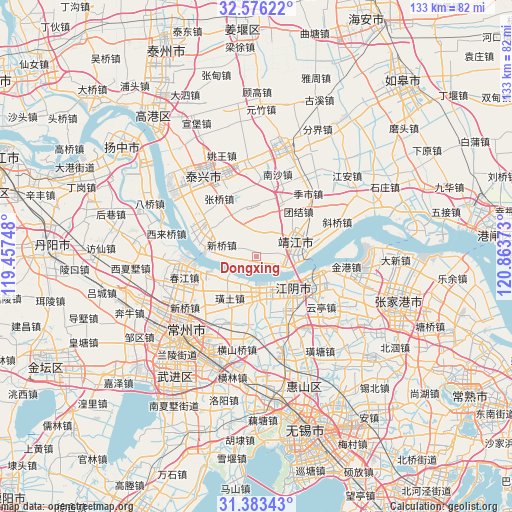
Dongxing GPS coordinates[2]
31° 58' 54.336" North, 120° 9' 38.16" East
| Map corner | latitude | longitude |
|---|---|---|
| Upper-left | 32.57622°, | 119.45748° |
| Center: | 31.98176°, | 120.1606° |
| Lower-right: | 31.38343°, | 120.86373° |
| Map W x H: | 132.6×132.6 km | = 82.4×82.4mi |
| max Lat: | 53.31946° ⇑39% North |
| Dongxing: | 31.98176° |
| min Lat: | ⇓61% South 18.22056° |
| min Long | Dongxing | max Long |
| 75.07348° | 120.1606° | 134.28917° |
| W 82.9%⇐ | ⇒17.1% E |
Elevation
Elevation of Dongxing is 4 m = 13 ft, and this is 480.8 m = 1577 ft below average elevation for this country.
| Max E: |
5622 m = 18445 ft | 98.3% |
| Avg. | 484.8 m = 1591 ft | |
| Dongxing | 4 m = 13 ft | |
Min E: |
-3 m = -10 ft | 1.7% |
See also: China elevation on elevation.city.
Geographical zone
Dongxing is located in North temperate zone (between Tropic of Cancer and the Arctic Circle). Distance of this Northern Tropic circle is 950.1 km =590.4 mi to South.| Distance of | km | miles | from Dongxing |
|---|---|---|---|
| North Pole | 6451 | 4008.5 | to North |
| Arctic Circle | 3845.1 | 2389.2 | to North |
| Tropic Cancer | 950.1 | 590.4 | to South |
| Equator | 3556 | 2209.6 | to South |


Nearby cities:
15 places around Dongxing: (largest is in red/bold)
• Changdai
8 km =5 mi,  41°
41°
• Guangling
15.4 km =9.6 mi,  27°
27°
• Hongguang
10.4 km =6.5 mi,  330°
330°
• Jiangyin
12.5 km =7.8 mi,  129°
129°
• Jingjiang
10.3 km =6.4 mi,  69°
69°
• Ligang
10 km =6.2 mi,  230°
230°
• Qixu
14.7 km =9.1 mi,  290°
290°
• Quxia
13.2 km =8.2 mi,  358°
358°
• Shengang
10.8 km =6.7 mi,  191°
191°
• Shengci
6.1 km =3.8 mi,  2°
2°
• Shizhuang
14.6 km =9.1 mi,  241°
241°
• Xiagang
10.5 km =6.5 mi,  153°
153°
• Xinqiao
9.1 km =5.7 mi, 285°
• Xishiqiao
14.3 km =8.9 mi,  208°
208°
• Yaosai
14.3 km =8.9 mi, 126°
Sources, notices
• [Note1] Compared only with cities in China existing in our database
• [Src1] Map data: © OpenStreetMap contributors (CC-BY-SA)
• [Src2] Other city data from geonames.org with taken over terms of usage.
• [Src3] Geographical zone / Annual Mean Temperature by Robert A. Rohde @ Wikipedia
