Shuzi geodata
Shuzi (Guangdong) is a seat of a fourth-order administrative division; located in China in Asia/Urumqi (GMT+6) time zone. In our database, there are 1268 cities with bigger population. Compared to other cities in China, 98% of cities are located further ↑North; 66.2% of cities are located further →East and 78.3% of cities have higher elevation than Shuzi. Note1


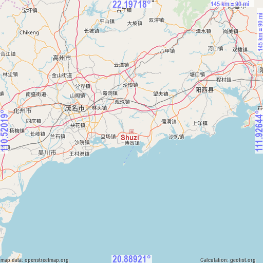
Shuzi GPS coordinates[2]
21° 32' 40.812" North, 111° 13' 23.916" East
| Map corner | latitude | longitude |
|---|---|---|
| Upper-left | 22.19718°, | 110.52019° |
| Center: | 21.54467°, | 111.22331° |
| Lower-right: | 20.88921°, | 111.92644° |
| Map W x H: | 145.4×145.4 km | = 90.3×90.3mi |
| max Lat: | 53.31946° ⇑98% North |
| Shuzi: | 21.54467° |
| min Lat: | ⇓2% South 18.22056° |
| min Long | Shuzi | max Long |
| 75.07348° | 111.22331° | 134.28917° |
| W 33.8%⇐ | ⇒66.2% E |
Elevation
Elevation of Shuzi is 30 m = 98 ft, and this is 454.8 m = 1492 ft below average elevation for this country.
| Max E: |
5622 m = 18445 ft | 78.3% |
| Avg. | 484.8 m = 1591 ft | |
| Shuzi | 30 m = 98 ft | |
Min E: |
-3 m = -10 ft | 21.7% |
See also: China elevation on elevation.city.
Geographical zone
Shuzi is located in North Torrid zone (between Equator and Tropic of Cancer). Distance of this Northern Tropic circle is 210.4 km =130.7 mi to North.| Distance of | km | miles | from Shuzi |
|---|---|---|---|
| North Pole | 7611.5 | 4729.6 | to North |
| Arctic Circle | 5005.6 | 3110.3 | to North |
| Tropic Cancer | 210.4 | 130.7 | to North |
| Equator | 2395.5 | 1488.5 | to South |


Nearby cities:
15 places around Shuzi: (largest is in red/bold)
• Bohe
6.1 km =3.8 mi,  184°
184°
• Danchang
13.1 km =8.1 mi,  254°
254°
• Diancheng
8.5 km =5.3 mi,  111°
111°
• Gaodi
25.2 km =15.7 mi,  258°
258°
• Guanzhu
17 km =10.6 mi,  342°
342°
• Lingmen
17.2 km =10.7 mi,  80°
80°
• Lintou
22.5 km =14 mi,  306°
306°
• Magang
5.7 km =3.5 mi,  271°
271°
• Mata
14.5 km =9 mi,  61°
61°
• Nanhai
21.9 km =13.6 mi, 248°
• Poxin
25.1 km =15.6 mi,  295°
295°
• Qijing
23.9 km =14.9 mi,  276°
276°
• Rudong
22.6 km =14 mi,  74°
74°
• Shuidong
23.2 km =14.4 mi, 261°
• Xiadong
24 km =14.9 mi,  330°
330°
Sources, notices
• [Note1] Compared only with cities in China existing in our database
• [Src1] Map data: © OpenStreetMap contributors (CC-BY-SA)
• [Src2] Other city data from geonames.org with taken over terms of usage.
• [Src3] Geographical zone / Annual Mean Temperature by Robert A. Rohde @ Wikipedia
