Shangyong geodata
Shangyong (Fujian) is a seat of a fourth-order administrative division; located in China in Asia/Shanghai (GMT+8) time zone. In our database, there are 1268 cities with bigger population. Compared to other cities in China, 83.4% of cities are located further ↑North; 71.3% of cities are located further ←West and 81.3% of cities have lower elevation than Shangyong. Note1


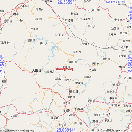
Shangyong GPS coordinates[2]
25° 44' 3.156" North, 118° 9' 25.776" East
| Map corner | latitude | longitude |
|---|---|---|
| Upper-left | 26.3659°, | 117.45404° |
| Center: | 25.73421°, | 118.15716° |
| Lower-right: | 25.09914°, | 118.86029° |
| Map W x H: | 140.9×140.9 km | = 87.6×87.6mi |
| max Lat: | 53.31946° ⇑83.4% North |
| Shangyong: | 25.73421° |
| min Lat: | ⇓16.6% South 18.22056° |
| min Long | Shangyong | max Long |
| 75.07348° | 118.15716° | 134.28917° |
| W 71.3%⇐ | ⇒28.7% E |
Elevation
Elevation of Shangyong is 758 m = 2487 ft, and this is 273.2 m = 896 ft above average elevation for this country.
| Max E: |
5622 m = 18445 ft | 18.7% |
| Shangyong | 758 m 2487 ft | |
| Avg. | 484.8 m = 1591 ft | |
Min E: |
-3 m = -10 ft | 81.3% |
See also: China elevation on elevation.city.
Geographical zone
Shangyong is located in North temperate zone (between Tropic of Cancer and the Arctic Circle). Distance of this Northern Tropic circle is 255.5 km =158.8 mi to South.| Distance of | km | miles | from Shangyong |
|---|---|---|---|
| North Pole | 7145.7 | 4440.1 | to North |
| Arctic Circle | 4539.8 | 2820.9 | to North |
| Tropic Cancer | 255.5 | 158.8 | to South |
| Equator | 2861.4 | 1778 | to South |


Nearby cities:
15 places around Shangyong: (largest is in red/bold)
• Chishui
10.3 km =6.4 mi,  196°
196°
• Chunmei
17.3 km =10.7 mi,  251°
251°
• Daming
9.2 km =5.7 mi,  238°
238°
• Gaide
25.2 km =15.7 mi,  176°
176°
• Gekeng
13.3 km =8.3 mi,  19°
19°
• Guiyang
8.2 km =5.1 mi,  59°
59°
• Guobao
14 km =8.7 mi,  171°
171°
• Huaxing
27.6 km =17.1 mi,  260°
260°
• Humei
23.3 km =14.5 mi,  286°
286°
• Leifeng
22.3 km =13.9 mi,  142°
142°
• Meihu
15.4 km =9.6 mi,  210°
210°
• Nancheng
25.2 km =15.7 mi,  115°
115°
• Shuikou
27.5 km =17.1 mi,  95°
95°
• Tangtou
8.3 km =5.2 mi,  342°
342°
• Xunzhong
27.9 km =17.3 mi,  162°
162°
Sources, notices
• [Note1] Compared only with cities in China existing in our database
• [Src1] Map data: © OpenStreetMap contributors (CC-BY-SA)
• [Src2] Other city data from geonames.org with taken over terms of usage.
• [Src3] Geographical zone / Annual Mean Temperature by Robert A. Rohde @ Wikipedia
