Xincheng geodata
Xincheng (Henan) is a seat of a third-order administrative division; located in China in Asia/Shanghai (GMT+8) time zone. In our database, there are 1268 cities with bigger population. Compared to other cities in China, 68.2% of cities are located further ↓South; 52.1% of cities are located further ←West and 70.8% of cities have higher elevation than Xincheng. Note1


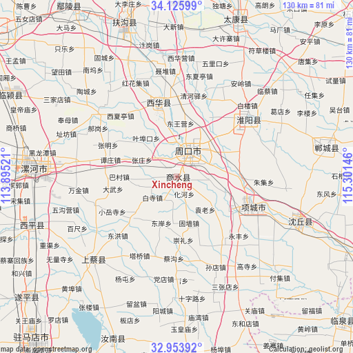
Xincheng GPS coordinates[2]
33° 32' 30.984" North, 114° 35' 53.988" East
| Map corner | latitude | longitude |
|---|---|---|
| Upper-left | 34.12599°, | 113.89521° |
| Center: | 33.54194°, | 114.59833° |
| Lower-right: | 32.95392°, | 115.30146° |
| Map W x H: | 130.3×130.3 km | = 81×81mi |
| max Lat: | 53.31946° ⇑31.8% North |
| Xincheng: | 33.54194° |
| min Lat: | ⇓68.2% South 18.22056° |
| min Long | Xincheng | max Long |
| 75.07348° | 114.59833° | 134.28917° |
| W 52.1%⇐ | ⇒47.9% E |
Elevation
Elevation of Xincheng is 49 m = 161 ft, and this is 435.8 m = 1430 ft below average elevation for this country.
| Max E: |
5622 m = 18445 ft | 70.8% |
| Avg. | 484.8 m = 1591 ft | |
| Xincheng | 49 m = 161 ft | |
Min E: |
-3 m = -10 ft | 29.2% |
See also: China elevation on elevation.city.
Geographical zone
Xincheng is located in North temperate zone (between Tropic of Cancer and the Arctic Circle). Distance of this Northern Tropic circle is 1123.6 km =698.2 mi to South.| Distance of | km | miles | from Xincheng |
|---|---|---|---|
| North Pole | 6277.5 | 3900.7 | to North |
| Arctic Circle | 3671.7 | 2281.5 | to North |
| Tropic Cancer | 1123.6 | 698.2 | to South |
| Equator | 3729.5 | 2317.4 | to South |


Nearby cities:
15 places around Xincheng: (largest is in red/bold)
• Baicheng
56.7 km =35.2 mi,  252°
252°
• Chongyang
45.6 km =28.3 mi,  226°
226°
• Dizhuang
49.1 km =30.5 mi,  272°
272°
• Dongcheng
47 km =29.2 mi,  107°
107°
• Fugou Chengguanzhen
61.6 km =38.3 mi,  341°
341°
• Ganhechen
53.6 km =33.3 mi, 271°
• Huaidian
42.1 km =26.2 mi, 106°
• Huaiyang Chengguanzhen
33.9 km =21.1 mi,  51°
51°
• Huayuan
26.7 km =16.6 mi, 107°
• Luohe
51.5 km =32 mi, 272°
• Songji
58.6 km =36.4 mi,  261°
261°
• Wacheng
27.9 km =17.3 mi, 344°
• Xincheng
55.1 km =34.2 mi,  79°
79°
• Yancheng Chengguanzhen
56.9 km =35.4 mi, 274°
• Zhoukou
10.7 km =6.6 mi,  17°
17°
Sources, notices
• [Note1] Compared only with cities in China existing in our database
• [Src1] Map data: © OpenStreetMap contributors (CC-BY-SA)
• [Src2] Other city data from geonames.org with taken over terms of usage.
• [Src3] Geographical zone / Annual Mean Temperature by Robert A. Rohde @ Wikipedia
