Xincheng geodata
Xincheng (Henan) is a seat of a third-order administrative division; located in China in Asia/Shanghai (GMT+8) time zone. With population of 65,411 people, there are 664 cities with bigger population in this country. Compared to other cities in China, 68.5% of cities are located further ↓South; 55.3% of cities are located further ←West and 72.7% of cities have higher elevation than Xincheng. Note1


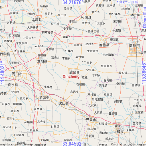
Xincheng GPS coordinates[2]
33° 37' 59.988" North, 115° 10' 59.988" East
| Map corner | latitude | longitude |
|---|---|---|
| Upper-left | 34.21676°, | 114.48021° |
| Center: | 33.63333°, | 115.18333° |
| Lower-right: | 33.04592°, | 115.88646° |
| Map W x H: | 130.2×130.2 km | = 80.9×80.9mi |
| max Lat: | 53.31946° ⇑31.5% North |
| Xincheng: | 33.63333° |
| min Lat: | ⇓68.5% South 18.22056° |
| min Long | Xincheng | max Long |
| 75.07348° | 115.18333° | 134.28917° |
| W 55.3%⇐ | ⇒44.7% E |
Elevation
Elevation of Xincheng is 43 m = 141 ft, and this is 441.8 m = 1449 ft below average elevation for this country.
| Max E: |
5622 m = 18445 ft | 72.7% |
| Avg. | 484.8 m = 1591 ft | |
| Xincheng | 43 m = 141 ft | |
Min E: |
-3 m = -10 ft | 27.3% |
See also: Xincheng elevation on elevation.city.
Geographical zone
Xincheng is located in North temperate zone (between Tropic of Cancer and the Arctic Circle). Distance of this Northern Tropic circle is 1133.8 km =704.5 mi to South.| Distance of | km | miles | from Xincheng |
|---|---|---|---|
| North Pole | 6267.4 | 3894.4 | to North |
| Arctic Circle | 3661.5 | 2275.1 | to North |
| Tropic Cancer | 1133.8 | 704.5 | to South |
| Equator | 3739.7 | 2323.7 | to South |


Nearby cities:
15 places around Xincheng: (largest is in red/bold)
• Bozhou
60.7 km =37.7 mi,  63°
63°
• Dongcheng
26.3 km =16.3 mi,  201°
201°
• Huaidian
26.2 km =16.3 mi,  212°
212°
• Huaiyang Chengguanzhen
29.9 km =18.6 mi,  291°
291°
• Huayuan
34.1 km =21.2 mi,  237°
237°
• Jieshou
44.3 km =27.5 mi,  158°
158°
• Jishui
22.9 km =14.2 mi, 60°
• Linquan Chengguanzhen
61.8 km =38.4 mi,  170°
170°
• Taihe Chengguanzhen
67.6 km =42 mi,  140°
140°
• Taikang Chengguanzhen
56.4 km =35 mi,  328°
328°
• Wacheng
63.9 km =39.7 mi, 285°
• Xiguan
36.9 km =22.9 mi,  45°
45°
• Xincheng
55.1 km =34.2 mi,  259°
259°
• Zhecheng Chengguanzhen
53.8 km =33.4 mi,  13°
13°
• Zhoukou
50.9 km =31.6 mi,  270°
270°
Sources, notices
• [Note1] Compared only with cities in China existing in our database
• [Src1] Map data: © OpenStreetMap contributors (CC-BY-SA)
• [Src2] Other city data from geonames.org with taken over terms of usage.
• [Src3] Geographical zone / Annual Mean Temperature by Robert A. Rohde @ Wikipedia
