Shajing geodata
Shajing (Guangdong) is a seat of a fourth-order administrative division; located in China in Asia/Shanghai (GMT+8) time zone. In our database, there are 1268 cities with bigger population. Compared to other cities in China, 91.8% of cities are located further ↑North; 50.8% of cities are located further →East and 71.9% of cities have higher elevation than Shajing. Note1


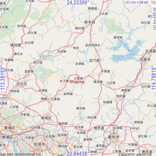
Shajing GPS coordinates[2]
23° 35' 25.152" North, 114° 5' 42.18" East
| Map corner | latitude | longitude |
|---|---|---|
| Upper-left | 24.23309°, | 113.39193° |
| Center: | 23.59032°, | 114.09505° |
| Lower-right: | 22.94438°, | 114.79818° |
| Map W x H: | 143.3×143.3 km | = 89×89mi |
| max Lat: | 53.31946° ⇑91.8% North |
| Shajing: | 23.59032° |
| min Lat: | ⇓8.2% South 18.22056° |
| min Long | Shajing | max Long |
| 75.07348° | 114.09505° | 134.28917° |
| W 49.2%⇐ | ⇒50.8% E |
Elevation
Elevation of Shajing is 45 m = 148 ft, and this is 439.8 m = 1443 ft below average elevation for this country.
| Max E: |
5622 m = 18445 ft | 71.9% |
| Avg. | 484.8 m = 1591 ft | |
| Shajing | 45 m = 148 ft | |
Min E: |
-3 m = -10 ft | 28.1% |
See also: China elevation on elevation.city.
Geographical zone
Shajing is located in North temperate zone (between Tropic of Cancer and the Arctic Circle). Distance of this Northern Tropic circle is 17.1 km =10.6 mi to South.| Distance of | km | miles | from Shajing |
|---|---|---|---|
| North Pole | 7384.1 | 4588.3 | to North |
| Arctic Circle | 4778.2 | 2969 | to North |
| Tropic Cancer | 17.1 | 10.6 | to South |
| Equator | 2623 | 1629.9 | to South |


Nearby cities:
15 places around Shajing: (largest is in red/bold)
• Dipa
28.6 km =17.8 mi,  357°
357°
• Gongzhuang
29.7 km =18.5 mi,  102°
102°
• Henghe
27.5 km =17.1 mi,  175°
175°
• Longcheng
22.4 km =13.9 mi,  44°
44°
• Longhua
10.4 km =6.5 mi,  76°
76°
• Longjiang
20.8 km =12.9 mi,  85°
85°
• Longtan
13.7 km =8.5 mi,  4°
4°
• Longtian
23.8 km =14.8 mi, 41°
• Luxi
18.5 km =11.5 mi, 99°
• Lütian
29 km =18 mi,  327°
327°
• Mazha
17.8 km =11.1 mi,  209°
209°
• Pingling
26.2 km =16.3 mi,  74°
74°
• Wangping
22.4 km =13.9 mi, 44°
• Yonghan
12.8 km =8 mi,  260°
260°
• Zhengguo
28.3 km =17.6 mi,  226°
226°
Sources, notices
• [Note1] Compared only with cities in China existing in our database
• [Src1] Map data: © OpenStreetMap contributors (CC-BY-SA)
• [Src2] Other city data from geonames.org with taken over terms of usage.
• [Src3] Geographical zone / Annual Mean Temperature by Robert A. Rohde @ Wikipedia
